IMAGES TAKEN NEAR TO
Westhall Road, WARLINGHAM, CR6 9BG
Introduction
This page details the photographs taken nearby to Westhall Road, CR6 9BG by members of the Geograph project.
The Geograph project started in 2005 with the aim of publishing, organising and preserving representative images for every square kilometre of Great Britain, Ireland and the Isle of Man.

There are currently over 7.5m images from over14,400 individuals and you can help contribute to the project by visiting https://www.geograph.org.uk
Image Map
Images are licensed for reuse under creativecommons.org/licenses/by-sa/2.0
Notes
- Clicking on the map will re-center to the selected point.
- The higher the marker number, the further away the image location is from the centre of the postcode.
Image Listing (20 Images Found)
Images are licensed for reuse under creativecommons.org/licenses/by-sa/2.0
Image
Details
Distance
1
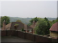
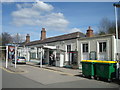
House roofs beside Westhall Road
Looking down the valleyside towards Whyteleafe.
Image: © David Anstiss
Taken: 6 Sep 2014
0.09 miles
2
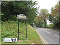
Warlingham Village Sign on Westhall Road
This metal painted sign is on the junction of Oakley Road (heading left towards Court Farm Road) and Westhall Road.
Image: © David Anstiss
Taken: 6 Sep 2014
0.09 miles
3
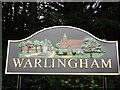
Warlingham Village Sign
Metal painted sign on the corner of Oakley Road and Westhall Road.
See http://www.geograph.org.uk/photo/4163022
Displays http://www.geograph.org.uk/photo/4162313 and http://www.geograph.org.uk/photo/23435
Image: © David Anstiss
Taken: 6 Sep 2014
0.09 miles
4
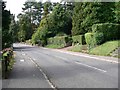
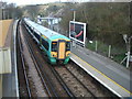
Warlingham - Westhall Road
A typical residential road in this area, looking downhill as the roads goes towards Whyteleafe.
Image: © Richard Mascall
Taken: 16 Sep 2005
0.14 miles
7
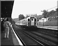
Upper Warlingham station
On the first day of electric services on the East Grinstead line, a '4-CIG' unit is seen on a Down working.
Image: © Dr Neil Clifton
Taken: 27 Sep 1987
0.18 miles
9
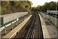
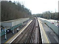
Upper Warlingham Railway Station
Looking in the Oxted (down) direction. The line continues to East Grinstead and Uckfield.
Image: © Peter Trimming
Taken: 20 Oct 2015
0.19 miles
10
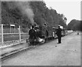
Miniature railway at Upper Warlingham
27 September 1987 was the first day of electric operation to East Grinstead on the (then) Southern Region of British Railways. To celebrate this auspicious occasion, various events were arranged at stations along the line, including the provision of this small railway at Upper Warlingham. Perhaps it was not well publicised, but it seemed that few children turned up to see it.
Image: © Dr Neil Clifton
Taken: 27 Sep 1987
0.20 miles