IMAGES TAKEN NEAR TO
Pigeon House Lane, COULSDON, CR5 3SP
Introduction
This page details the photographs taken nearby to Pigeon House Lane, CR5 3SP by members of the Geograph project.
The Geograph project started in 2005 with the aim of publishing, organising and preserving representative images for every square kilometre of Great Britain, Ireland and the Isle of Man.

There are currently over 7.5m images from over14,400 individuals and you can help contribute to the project by visiting https://www.geograph.org.uk
Image Map (Loading...)


Getting Data...Please wait
Leaflet Map data © OpenStreetMap
Images are licensed for reuse under creativecommons.org/licenses/by-sa/2.0
Notes
- Clicking on the map will re-center to the selected point.
- The higher the marker number, the further away the image location is from the centre of the postcode.
Image Listing (49 Images Found)
Images are licensed for reuse under creativecommons.org/licenses/by-sa/2.0
Image
Details
Distance
1
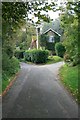
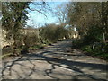
Kingswood Kennels, Pigeonhouse Lane
Two footpaths, Banstead 135 and 136, leave the lane just next to the drive on the right, and another (well hidden), 132, to the left, just behind the photographer.
Image: © Hugh Craddock
Taken: 19 Oct 2008
0.02 miles
2
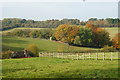
View Towards Kingswood
Picture taken from Mugswell. The building, to the left of picture, is on a sunken lane, and has an adjoining kennels. Kingswood is just over the brow of the distant hill; housing hidden by the belt of woodland.
Image: © Peter Trimming
Taken: 30 Oct 2009
0.06 miles
3
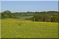
West from Southerns Lane
On the left skyline is the steeple of St Andrew's Church, Kingswood.
Image: © Ian Capper
Taken: 23 May 2010
0.09 miles
4
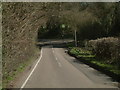
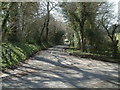
Chipstead Lane, Eastern End
Chipstead Lane looking towards its junction with Pigeonhouse Lane and White Hill.
Image: © John Hilton
Taken: 11 Mar 2007
0.09 miles
5
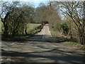
White Hill from Pigeonhouse Lane
White Hill viewed from the junction of Pigeonhouse Lane and Chipstead Lane.
Image: © John Hilton
Taken: 11 Mar 2007
0.11 miles
6
Pigeonhouse Lane, Mugswell
Pigeonhouse Lane, Mugswell viewed from White Hill
Image: © John Hilton
Taken: 11 Mar 2007
0.11 miles
7
Chipstead Lane viewed from White Hill
The junction of Chipstead Lane, Pigeonhouse Lane and White Hill viewed from White Hill.
Image: © John Hilton
Taken: 11 Mar 2007
0.11 miles
8
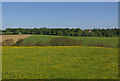
North from Southerns Lane
On the skyline is part of the development of Eyhurst Park.
Image: © Ian Capper
Taken: 23 May 2010
0.13 miles
9

April Cottage from Wellfield Shaw
View from public footpath Banstead 136 below Wellfield Shaw across Pigeonhouse Lane.
Image: © Hugh Craddock
Taken: 19 Oct 2008
0.14 miles
10
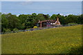
April Cottage, Mugswell, Surrey
April Cottage lies just off Southerns Lane. Photographed from Rectory Road.
Image: © Peter Trimming
Taken: 24 May 2011
0.15 miles