IMAGES TAKEN NEAR TO
How Lane, COULSDON, CR5 3LN
Introduction
This page details the photographs taken nearby to How Lane, CR5 3LN by members of the Geograph project.
The Geograph project started in 2005 with the aim of publishing, organising and preserving representative images for every square kilometre of Great Britain, Ireland and the Isle of Man.

There are currently over 7.5m images from over14,400 individuals and you can help contribute to the project by visiting https://www.geograph.org.uk
Image Map (Loading...)


Getting Data...Please wait
Leaflet Map data © OpenStreetMap
Images are licensed for reuse under creativecommons.org/licenses/by-sa/2.0
Notes
- Clicking on the map will re-center to the selected point.
- The higher the marker number, the further away the image location is from the centre of the postcode.
Image Listing (29 Images Found)
Images are licensed for reuse under creativecommons.org/licenses/by-sa/2.0
Image
Details
Distance
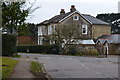
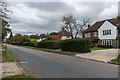
1

Nutana and How Hatch, How Lane
Two houses in How Lane, opposite Hollymead Road. How Hatch (the further of the two) first appears on the 1913 1:2,500 map, whereas according to recent planning document Nutana was built in the 1980s.
Image: © Ian Capper
Taken: 27 Oct 2018
0.04 miles
2
Hollymead Road
Road shown as laid out (and individual plots marked) but not yet developed on the 1913 1:2,500 map.
Image: © Ian Capper
Taken: 27 Oct 2018
0.06 miles
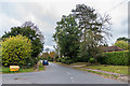
3
Junction of Hollymead Road and How Lane
Image: © David Martin
Taken: 14 Mar 2015
0.07 miles
4
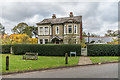
Holly Lodge
Edwardian house on How Green in How Lane, first appearing on the 1913 1:2,500 map.
Image: © Ian Capper
Taken: 27 Oct 2018
0.07 miles
5
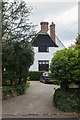
Blackthorne Cottage
House in How Lane, first shown on the 1913 1:2,500 map.
Image: © Ian Capper
Taken: 27 Oct 2018
0.08 miles
6
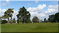
Chipstead Golf Course
Golfers in the distance, and a bunker lurking in the foreground.
Image: © Peter Trimming
Taken: 29 Mar 2009
0.09 miles
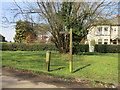
8
Hollymead Road
Road shown as laid out (and individual plots marked) but not yet developed on the 1913 1:2,500 map.
Image: © Ian Capper
Taken: 27 Oct 2018
0.11 miles
9
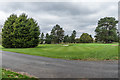
Chipstead golf course
Part of Chipstead golf course, laid out in 1905.
Image: © Ian Capper
Taken: 27 Oct 2018
0.11 miles
10
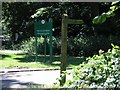
Bridleway & Golf Club entrance
The start of a public bridleway and also the entrance to Chipstead Golf Club
Image: © Hywel Williams
Taken: 12 Jul 2005
0.11 miles