IMAGES TAKEN NEAR TO
Starrock Road, COULSDON, CR5 3EH
Introduction
This page details the photographs taken nearby to Starrock Road, CR5 3EH by members of the Geograph project.
The Geograph project started in 2005 with the aim of publishing, organising and preserving representative images for every square kilometre of Great Britain, Ireland and the Isle of Man.

There are currently over 7.5m images from over14,400 individuals and you can help contribute to the project by visiting https://www.geograph.org.uk
Image Map
Images are licensed for reuse under creativecommons.org/licenses/by-sa/2.0
Notes
- Clicking on the map will re-center to the selected point.
- The higher the marker number, the further away the image location is from the centre of the postcode.
Image Listing (26 Images Found)
Images are licensed for reuse under creativecommons.org/licenses/by-sa/2.0
Image
Details
Distance
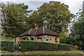
1
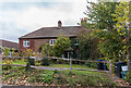
Stoney Cottage
Cottage on Hollymeoak Road divided into two parts. A date plaque on the wall gives a date of 1799.
Hollymeoak Road was originally marked as Hollyme Oak Road, Hollyme Oak being the old name for Holm Oak.
Image: © Ian Capper
Taken: 27 Oct 2018
0.10 miles
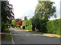
2
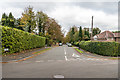
Starrock Road
Road shown as laid out but not yet developed on the 1912-3 1:2,500 map, along the line of previous footpath.
Image: © Ian Capper
Taken: 27 Oct 2018
0.11 miles
3
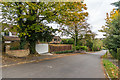
Woodfield Hill
Road shown as laid out but with only a couple of houses on the 1912-3 1:2,500 map.
Image: © Ian Capper
Taken: 27 Oct 2018
0.12 miles
4
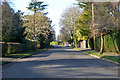
Woodfield Hill
The road has a 20 limit, quite frequently applied in these parts.
Image: © Robin Webster
Taken: 18 Jan 2020
0.13 miles
5
Woodfield Hill
This is the view just up from the junction with Brighton Road (A23).
Image: © Marathon
Taken: 24 Aug 2023
0.13 miles
6
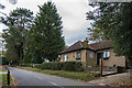
Portnalls Lodge
Lodge on Hollymeoak Road first appearing on the 1896 1:2,500 map, as does the house is served, Portnalls, shown on the same map as having been built near the much older Portnalls Farm. Portnalls burnt down in October 1987.
Hollymeoak Road was originally marked as Hollyme Oak Road, Hollyme Oak being the old name for Holm Oak.
Image: © Ian Capper
Taken: 27 Oct 2018
0.13 miles
7
Portnalls Lodge
Lodge on Hollymeoak Road first appearing on the 1896 1:2,500 map, as does the house is served, Portnalls, shown on the same map as having been built near the much older Portnalls Farm. Portnalls burnt down in October 1987.
Hollymeoak Road was originally marked as Hollyme Oak Road, Hollyme Oak being the old name for Holm Oak.
Image: © Ian Capper
Taken: 27 Oct 2018
0.13 miles
8
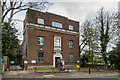
Coulsdon Telephone Exchange
Telephone exchange on Hollymeoak Road, serving the "Downland" code area (01737 5). It dates from 1930.
Hollymeoak Road was originally marked as Hollyme Oak Road, Hollyme Oak being the old name for Holm Oak.
Image: © Ian Capper
Taken: 27 Oct 2018
0.13 miles
9
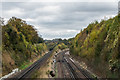
Brighton Lines
The Brighton Lines from Woodplace Lane Bridge. On the left is the original Brighton Line through Redhill, built in 1841, and on the right is the 1899 Quarry Line, bypassing Redhill. In the distance is the bridge where the latter crosses the former, with the Quarry Line running to the west of the original line until they meet again near Earlswood.
Image: © Ian Capper
Taken: 27 Oct 2018
0.14 miles
10
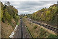
Brighton Lines
The Brighton Lines from Woodplace Lane Bridge. On the left is the original Brighton Line through Redhill, built in 1841, and on the right is the 1899 Quarry Line, bypassing Redhill. In the distance is the bridge where the latter crosses the former, with the Quarry Line running to the west of the original line until they meet again near Earlswood.
Image: © Ian Capper
Taken: 27 Oct 2018
0.14 miles