IMAGES TAKEN NEAR TO
Portnalls Road, COULSDON, CR5 3DD
Introduction
This page details the photographs taken nearby to Portnalls Road, CR5 3DD by members of the Geograph project.
The Geograph project started in 2005 with the aim of publishing, organising and preserving representative images for every square kilometre of Great Britain, Ireland and the Isle of Man.

There are currently over 7.5m images from over14,400 individuals and you can help contribute to the project by visiting https://www.geograph.org.uk
Image Map
Images are licensed for reuse under creativecommons.org/licenses/by-sa/2.0
Notes
- Clicking on the map will re-center to the selected point.
- The higher the marker number, the further away the image location is from the centre of the postcode.
Image Listing (21 Images Found)
Images are licensed for reuse under creativecommons.org/licenses/by-sa/2.0
Image
Details
Distance
1
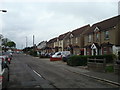
Vincent Road, Coulsdon
Vincent Road is a residential road in Coulsdon, on the outer fringe of south London.
Image: © Malc McDonald
Taken: 11 Jan 2020
0.05 miles
2
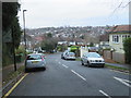
Portnalls Rise, Coulsdon
Portnalls Rise is a residential road in Coulsdon, on the outer fringe of south London.
Image: © Malc McDonald
Taken: 11 Jan 2020
0.10 miles
3
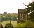
The Towers Of Coulsdon
Cane Hill water tower was fed water by a bore hole within a building called Sovereign House that still exists today within Lion Green car park and before this used as a laundry house. It once pumped water half a mile up hill and in and up to the water tower. They used to bore big holes down into the local chalk and water would find its way out of the fissures within the chalk to form a well so that could be used. This is where the water came from back in 1882 and the last date of service for this well house was in 1987.
The second tower is the top of St Andrews Church with is flag flying proudly.
I've seen this view so many times whilst driving down the hill thinking I wish I had my camera, well on this day I did but it was my rubbish camera that I carry everywhere. Teach me not to get my grand camera fixed after dropping it on a solid concrete floor. Sorry for the poor quality photo but I think it's a great view either way and makes you feel home as you drop down in to Coulsdon.
Image: © Martin Miles
Taken: 10 May 2010
0.10 miles
4
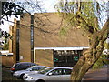
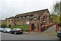
St. Aidan's Roman Catholic Church, Coulsdon
The first St. Aidan's in Coulsdon was opened in the early part of the 20th Century in the building which is now used as a Martial Arts Centre, see Image In 1966, the new church shown above was opened at the junction of Portnalls Road with Chipstead Valley Road.
Image: © Dr Neil Clifton
Taken: 14 Nov 2008
0.14 miles
5
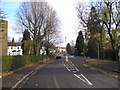
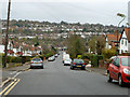
Portnalls Road, Coulsdon
Portnalls Road leads down from Chipstead Village to Chipstead Valley Road at Coulsdon. Here we see its northern end looking towards the Chipstead Valley Road junction, on a sunny November day. The big ash in the church grounds of St. Aidan's (on the left) has lost all its leaves, but other trees hang on.
Image: © Dr Neil Clifton
Taken: 14 Nov 2008
0.14 miles
7
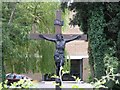
Crucifix outside Coulsdon Catholic Church
St. Aidan's Catholic Church, Coulsdon
Image: © Hywel Williams
Taken: 11 Jul 2005
0.17 miles
8
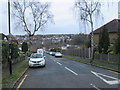
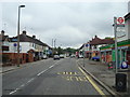
View down Rickman Hill
Shops on Chipstead Valley Road are at the bottom of the hill.
Image: © Robin Webster
Taken: 21 Nov 2010
0.17 miles
9
Saint Mary and Saint Shenouda Coptic Orthodox Church
On Rickman Hill, Woodmansterne.
Image: © Robin Webster
Taken: 21 Nov 2010
0.18 miles