IMAGES TAKEN NEAR TO
St. Davids, COULSDON, CR5 2XE
Introduction
This page details the photographs taken nearby to St. Davids, CR5 2XE by members of the Geograph project.
The Geograph project started in 2005 with the aim of publishing, organising and preserving representative images for every square kilometre of Great Britain, Ireland and the Isle of Man.

There are currently over 7.5m images from over14,400 individuals and you can help contribute to the project by visiting https://www.geograph.org.uk
Image Map (Loading...)


Getting Data...Please wait
Leaflet Map data © OpenStreetMap
Images are licensed for reuse under creativecommons.org/licenses/by-sa/2.0
Notes
- Clicking on the map will re-center to the selected point.
- The higher the marker number, the further away the image location is from the centre of the postcode.
Image Listing (9 Images Found)
Images are licensed for reuse under creativecommons.org/licenses/by-sa/2.0
Image
Details
Distance
2
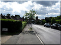
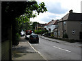
Coulsdon: Stoneyfield Road
Seen from its junction with Coulsdon Road. Stoneyfield Road gives a through connection to Marlpit Lane and Bradmore Way.
Image: © Dr Neil Clifton
Taken: 12 May 2011
0.14 miles
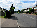
3

Marlpit Lane, Coulsdon
Looking towards Hillside Road, and it is on a major hill.
Image: © David Howard
Taken: 17 Nov 2013
0.20 miles
4
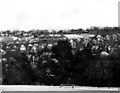
Former quarry, Coulsdon
Presumably for the extraction of chalk. Housing and an industrial estate now cover the site.
Image: © Stephen Richards
Taken: 21 Jan 2017
0.21 miles
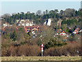
5
Old Coulsdon: Marlpit Lane
Looking downhill (northwest) from near the TA Centre
Image: © Dr Neil Clifton
Taken: 12 May 2011
0.22 miles
6
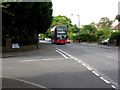
Old Coulsdon: Coulsdon Road
Looking downhill, i.e. northwest. One of Arriva's Tridents on Route 466 has just left the Stoneyfield Road stop on its way to Caterham-on-the-Hill.
Image: © Dr Neil Clifton
Taken: 12 May 2011
0.23 miles
8
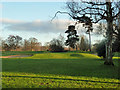
Fourteenth green, Coulsdon Court Golf Club
A 355 yards par 4 approached from the left.
Image: © Robin Webster
Taken: 30 Jan 2011
0.23 miles
9
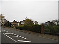
Old Coulsdon: Stanley Close
Off the southwest side of Coulsdon Road
Image: © Dr Neil Clifton
Taken: 12 May 2011
0.25 miles