IMAGES TAKEN NEAR TO
Grove Lane, COULSDON, CR5 2QD
Introduction
This page details the photographs taken nearby to Grove Lane, CR5 2QD by members of the Geograph project.
The Geograph project started in 2005 with the aim of publishing, organising and preserving representative images for every square kilometre of Great Britain, Ireland and the Isle of Man.

There are currently over 7.5m images from over14,400 individuals and you can help contribute to the project by visiting https://www.geograph.org.uk
Image Map (Loading...)


Getting Data...Please wait
Leaflet Map data © OpenStreetMap
Images are licensed for reuse under creativecommons.org/licenses/by-sa/2.0
Notes
- Clicking on the map will re-center to the selected point.
- The higher the marker number, the further away the image location is from the centre of the postcode.
Image Listing (17 Images Found)
Images are licensed for reuse under creativecommons.org/licenses/by-sa/2.0
Image
Details
Distance
1
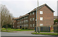
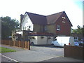
The Mount, Clock House Estate, Coulsdon
The Mount is one of the principal roads on this estate. Though administratively in the London Borough of Sutton, Clock House is separated from it by open country and is virtually part of Coulsdon in the adjoining Borough of Croydon.
Image: © David Kemp
Taken: 8 Apr 2015
0.09 miles
2
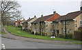
Houses in Beechwood Avenue, Coulsdon
I am not sure whether these houses form part of the Clock House estate or not.
Image: © David Kemp
Taken: 8 Apr 2015
0.11 miles
3
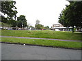
Hillcrest Parade, Woodmansterne
This is a little self-contained community in the middle of nowhere, as far as London goes anyway. It is totally surrounded by green spaces and has only one route in and out at each end.
Image: © David Howard
Taken: 15 Jun 2014
0.11 miles
5
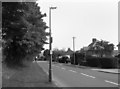
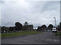
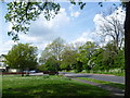
Grove Lane, Coulsdon
On the London Loop path, this is part of a 2km-ish length of roadside walking as the route goes through Coulsdon.
Loop waymark on the lamp post.
Really nondescript this, except that you get a choice of walking on paving or grass depending which side of the road you're on.
Image: © Des Blenkinsopp
Taken: 23 May 2012
0.12 miles
6
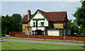
Jack & Jill pub, Longlands Avenue, Coulsdon
Image: © Noel Foster
Taken: 13 Sep 2005
0.13 miles
7
Jack & Jill, Clock House, Surrey
This pub appears to be in a rural location, but shops and houses are only a few yards away. Photographed across the small 'village' green.
Image: © Peter Trimming
Taken: 5 Jul 2011
0.14 miles
8
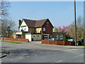
The Jack and Jill
On the corner of Grove Lane and Longlands Avenue.
Image: © Robin Webster
Taken: 30 Mar 2012
0.14 miles
9
Grove Lane from The Mount
Grove Lane is a road which then becomes a bridleway. It connects Coulsdon to Oaks Park. It is a very old track and was well-established by the latter half of the 18th century. It was then that the Twelfth Earl of Derby, and his sporting guests at The Oaks, used Grove Lane to ride down to the cricket ground at the Red Lion at Coulsdon to take part in the matches there.
Grove Lane is now followed by the London LOOP and where it becomes a bridleway provides magnificent views across London from Harrow-on-the-Hill and the Wembley Arch to The Shard and the City of London and further round to Canary Wharf. It has fine hedges and gives a glimpse of what much of Sutton must have been like in the 19th century. This is at the top of the hill out of Coulsdon by the appropriately-named Jack & Jill pub (seen here on the left). The road turns into the bridleway a little way ahead, downhill again - see http://www.geograph.org.uk/photo/3956661
Image: © Marathon
Taken: 30 Apr 2014
0.14 miles
10
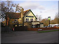
The 'Jack and Jill', Clock House, Sutton, Surrey
Appropriately, right at the top of the hill. The sign shows the tumbling children, with Jill displaying plenty of next week's washing.
Image: © Dr Neil Clifton
Taken: 2 Feb 2008
0.14 miles