IMAGES TAKEN NEAR TO
Station Approach, COULSDON, CR5 2NT
Introduction
This page details the photographs taken nearby to Station Approach, CR5 2NT by members of the Geograph project.
The Geograph project started in 2005 with the aim of publishing, organising and preserving representative images for every square kilometre of Great Britain, Ireland and the Isle of Man.

There are currently over 7.5m images from over14,400 individuals and you can help contribute to the project by visiting https://www.geograph.org.uk
Image Map
Images are licensed for reuse under creativecommons.org/licenses/by-sa/2.0
Notes
- Clicking on the map will re-center to the selected point.
- The higher the marker number, the further away the image location is from the centre of the postcode.
Image Listing (330 Images Found)
Images are licensed for reuse under creativecommons.org/licenses/by-sa/2.0
Image
Details
Distance
1

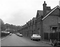
Station Approach Road, Coulsdon
It was originally the station approach road for Coulsdon North, long since demolished. This street had the distinction of being the very last street in the Borough of Croydon to be lit by gas. Electric street lighting replaced the gas in 1983.
Image: © Dr Neil Clifton
Taken: 18 Oct 2009
0.02 miles
2
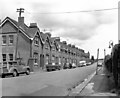
Station Approach Road, Coulsdon North
At the time of the photograph, this was the last remaining gas-lit street in the Borough of Croydon: the reason was that it was still lighted by the railway-owned gas supply to the neighbouring Coulsdon North station: presumably the local authority were happy to continue payment for the supply rather than change the lighting over to electricity.
Image: © Dr Neil Clifton
Taken: 27 May 1979
0.02 miles
3

Station Approach Road, Coulsdon
This street had the distinction of being the very last street in the Borough of Croydon to be lit by gas, a situation which persisted until September 1983 and arose because the street lighting was linked to the gas lighting at Coulsdon North station, (closed 30 September 1983).
Image: © Dr Neil Clifton
Taken: 10 Oct 2008
0.03 miles
4

Audi Coulsdon
Located off the Coulsdon By-Pass
Image: © Kurseong Carl
Taken: 24 May 2011
0.05 miles
5

Coulsdon Views
Taken from the top of St Andrews Church and from here you can really see that Coulsdon library was built in the shape of an open book.
Image: © Martin Miles
Taken: 17 Sep 2009
0.05 miles
6
Station Approach Road, with gas lamp
Looking up Station Approach Road, towards Coulsdon North station, one of the gas lamps still in use in 1979 is seen.
Image: © Dr Neil Clifton
Taken: 27 May 1979
0.05 miles
7

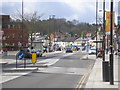
Brighton Road, Coulsdon
Looking northwards from outside the Library. The bus on Route 60 is a DLA of Arriva, on its way from Streatham to its southern terminus at Old Coulsdon (Tudor Rose).
Image: © Dr Neil Clifton
Taken: 10 Oct 2008
0.05 miles
8

Brighton Road, Coulsdon
The bus on its stand outside the Coulsdon Angling Centre is an Optare of Qualitiy Line buses (Epsom) at the southern end of its long route to Mitcham (Eastfields station). Route 463 has evolved from the 263, which began in the 1930s as Coulsdon North to Clock House Estate.
Image: © Dr Neil Clifton
Taken: 10 Oct 2008
0.06 miles
9

Brighton Road, junction with Chipstead Valley Road, Coulsdon
Image: © Stacey Harris
Taken: 10 Apr 2009
0.06 miles
10
Coulsdon: Brighton Road
Not very often as peaceful as this, taken looking south on a sunny April Sunday morning.
Image: © Dr Neil Clifton
Taken: 3 Apr 2011
0.06 miles