IMAGES TAKEN NEAR TO
Marlpit Lane, COULSDON, CR5 2HF
Introduction
This page details the photographs taken nearby to Marlpit Lane, CR5 2HF by members of the Geograph project.
The Geograph project started in 2005 with the aim of publishing, organising and preserving representative images for every square kilometre of Great Britain, Ireland and the Isle of Man.

There are currently over 7.5m images from over14,400 individuals and you can help contribute to the project by visiting https://www.geograph.org.uk
Image Map (Loading...)


Getting Data...Please wait
Leaflet Map data © OpenStreetMap
Images are licensed for reuse under creativecommons.org/licenses/by-sa/2.0
Notes
- Clicking on the map will re-center to the selected point.
- The higher the marker number, the further away the image location is from the centre of the postcode.
Image Listing (23 Images Found)
Images are licensed for reuse under creativecommons.org/licenses/by-sa/2.0
Image
Details
Distance
2
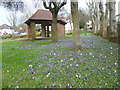
Crocuses and shelter in Chaldon Way Gardens
Chaldon Way Gardens was given to the Urban District Council by the developer, Fairdean Heights Ltd, who built the surrounding houses during the 1930s. The Company also allowed the Council to collect and use free of charge "such earth, turf, sub-soil, flowers and shrubs as can be removed from the Company's Fairdean Heights Estate" to create the Gardens. The ornamental garden were constructed with lawns, shrub beds and annual bedding displays, and a small shelter at one end of the garden. The shelter can be seen here along with a display of crocuses. Chaldon Way Gardens are in the angle formed by Marlpit Lane and Chaldon Way.
Image: © Marathon
Taken: 27 Mar 2013
0.15 miles
3

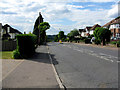
Marlpit Lane, Coulsdon
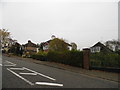
Looking towards Hillside Road, and it is on a major hill.
Image: © David Howard
Taken: 17 Nov 2013
0.15 miles
4
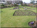
Chaldon Way Gardens
Chaldon Way Gardens was given to the Urban District Council by the developer, Fairdean Heights Ltd, who built the surrounding houses during the 1930s. The Company also allowed the Council to collect and use free of charge "such earth, turf, sub-soil, flowers and shrubs as can be removed from the Company's Fairdean Heights Estate" to create the Gardens. Chaldon Way Gardens are in the angle formed by Marlpit Lane and Chaldon Way.
Image: © Marathon
Taken: 27 Mar 2013
0.17 miles
5
Chaldon Way Gardens
Chaldon Way Gardens was given to the Urban District Council by the developer, Fairdean Heights Ltd, who built the surrounding houses during the 1930s. The Company also allowed the Council to collect and use free of charge "such earth, turf, sub-soil, flowers and shrubs as can be removed from the Company's Fairdean Heights Estate" to create the Gardens. Chaldon Way Gardens are in the angle formed by Marlpit Lane and Chaldon Way.
Image: © Marathon
Taken: 27 Mar 2013
0.18 miles
6
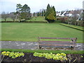
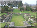
The bowling green at Coulsdon Memorial Ground
Coulsdon Memorial Ground was opened in 1921 after being purchased in 1920, partly by Coulsdon and Purley Urban District Council and partly by public subscription. The putting green area was purchased several years later. At the top of the hill there is a memorial which takes the form of a portico with a wall bearing the names of those killed in the two World Wars. This has the inscription "To the memory of the men of Coulsdon who fell in the Great War 1914-1919." A bronze plaque was added bearing the words "and in memory of those who fell in the World War 1939-1945."
To the rear of the recreation ground are deep chalk quarries which in the past had spur lines from the nearby railway running into the slopes to transport the extracted stone. This view looks across the bowling green from Marlpit Lane.
Image: © Marathon
Taken: 27 Mar 2013
0.19 miles
8
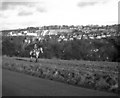
View From Downs Road, Coulsdon, Surrey
Looking up the road towards Farthing Downs. I'm standing on the gridline, and the left half of the photograph is in this gridsquare.
Image: © Peter Trimming
Taken: 4 Jul 2009
0.22 miles
9
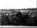
View from Farthing Downs, Coulsdon, Surrey
Image: © Dr Neil Clifton
Taken: 26 Dec 1977
0.22 miles
10
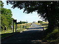
Old Coulsdon: Marlpit Lane
Looking downhill (northwest) from near the TA Centre
Image: © Dr Neil Clifton
Taken: 12 May 2011
0.22 miles