IMAGES TAKEN NEAR TO
The Avenue, COULSDON, CR5 2BN
Introduction
This page details the photographs taken nearby to The Avenue, CR5 2BN by members of the Geograph project.
The Geograph project started in 2005 with the aim of publishing, organising and preserving representative images for every square kilometre of Great Britain, Ireland and the Isle of Man.

There are currently over 7.5m images from over14,400 individuals and you can help contribute to the project by visiting https://www.geograph.org.uk
Image Map (Loading...)


Getting Data...Please wait
Leaflet Map data © OpenStreetMap
Images are licensed for reuse under creativecommons.org/licenses/by-sa/2.0
Notes
- Clicking on the map will re-center to the selected point.
- The higher the marker number, the further away the image location is from the centre of the postcode.
Image Listing (324 Images Found)
Images are licensed for reuse under creativecommons.org/licenses/by-sa/2.0
Image
Details
Distance
1
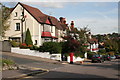
The Avenue, Coulsdon, Surrey (2)
Part of the way down The Avenue is the T-junction where The Grove comes in. This road runs to an end-on junction with The Drive, which the itself runs through to join Smithamdowns Road (B2030) at its lower end. The houses visible from here are Nos 10 to 2 (evens) The Avenue.
Image: © Dr Neil Clifton
Taken: 18 Oct 2007
0.01 miles
2
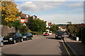
The Avenue, Coulsdon, Surrey
The Avenue runs downhill from its junction with Woodcote Grove Road (A237) at the top where the photographer is standing, to a junction with Brighton Road (A23) at the bottom. Here we see very large semi-detached houses which date from the inter-war period and are numbered from 26 down, (evens).
Image: © Dr Neil Clifton
Taken: 18 Oct 2007
0.04 miles
3
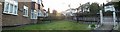
The Avenue, Panoramic
Was enjoying the sunset and decided to capture the moment.
Image: © Martin Miles
Taken: 4 Apr 2010
0.04 miles
4
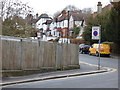
Coulsdon: The Avenue
Links from Brighton Road (A23) to the A237. Bus route 463 uses this road.
Image: © Dr Neil Clifton
Taken: 11 Mar 2018
0.05 miles
5
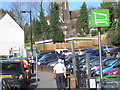
Cars, cars, cars and...even more cars
Malcolm Road, Coulsdon with Waitrose car park prominent. How long before cars proliferate to the extent at which they destroy the earth, like cancer cells destroying the human body?
Image: © Dr Neil Clifton
Taken: 3 Apr 2017
0.05 miles
6
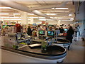
Coulsdon: Waitrose supermarket
For msny years, Waitrose was the only supermarket in Coulsdon, but now we have an ALDI and a Tesco Metro as well.
Image: © Dr Neil Clifton
Taken: 3 May 2017
0.05 miles

8
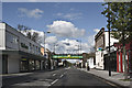
Coulsdon High Street
On a fine Sunday in April 2012
Image: © Kurseong Carl
Taken: 29 Apr 2012
0.06 miles
9
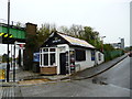
Coulsdon: Former coal office
This small building at the bottom of what is now called Leaden Hill (?Why?) has had several uses over the last few years, the latest as the 'Vape Pit' to promote the wholly-undesirable habit of 'Vaping' - (use of electronic cigarettes). Lest anyone reading this should be considering taking up this habit, I would remind them that it will hit them hard in the pocket and damage their health. The vapour contains nicotine and other related alkaloid drugs, so is highly addictive. It also contains formaldehyde, a known carcinogen. Be warned NOW, before it is too late. The only beneficiaries will be multi-billion pound corporations - and they won't pay your funeral expenses.
Image: © Dr Neil Clifton
Taken: 26 Apr 2015
0.06 miles
10
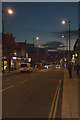
Autumn Evening
Coulsdon High street on an autumn evening
Image: © Kurseong Carl
Taken: 6 Nov 2010
0.06 miles