IMAGES TAKEN NEAR TO
Woodcote Grove Road, COULSDON, CR5 2AG
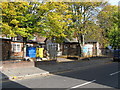
Introduction
This page details the photographs taken nearby to Woodcote Grove Road, CR5 2AG by members of the Geograph project.
The Geograph project started in 2005 with the aim of publishing, organising and preserving representative images for every square kilometre of Great Britain, Ireland and the Isle of Man.

There are currently over 7.5m images from over14,400 individuals and you can help contribute to the project by visiting https://www.geograph.org.uk
Image Map (224 Images)


Getting Data...Please wait
Leaflet Map data © OpenStreetMap
Images are licensed for reuse under creativecommons.org/licenses/by-sa/2.0
Notes
- Clicking on the map will re-center to the selected point.
- The higher the marker number, the further away the image location is from the centre of the postcode.
Image Listing (224 Images Found)
Images are licensed for reuse under creativecommons.org/licenses/by-sa/2.0
Image
Details
Distance
1
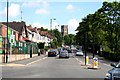
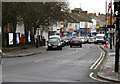
Coulsdon: Woodcote Grove Road
Looking north from Coulsdon Post Office, which stands at the intersection of the A237 (of which Woodcote Grove Road is a part) and the B2032 (Chipstead Valley Road). St. Andrew's Church is seen in the distance, while the peaked-roof building on the left of the road, now a Martial Arts centre, began life as Coulsdon's first Roman Catholic church.
Image: © Dr Neil Clifton
Taken: 24 Jul 2010
0.01 miles
2
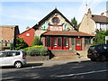
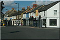
Coulsdon Martial Arts Centre, Woodcote Grove Road
This interesting building was built in the early part of the 20th Century, using dressed stones from a demolished barn at Stoats Nest Farm. It was originally St. Aidan's Roman Catholic Church, but after various problems the new St. Aidans finally opened in 1966 and the above building became a Co-operative Hall before assuming its present use as a Martial Arts centre.
Image: © Dr Neil Clifton
Taken: 10 Oct 2008
0.03 miles
3
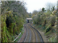
A sinuous course for the Tattenham Corner branch
The bridge carries Woodcote Grove Road. The viewpoint is a newly replaced footbridge.
Image: © Robin Webster
Taken: 21 Nov 2010
0.04 miles
4
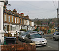
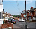
Woodman Road, Coulsdon
Coulsdon is not all tree-lined roads of pre-War semis of a kind outsiders might expect in this former part of Surrey.
Image: © David Kemp
Taken: 8 Apr 2015
0.05 miles
5
Former Smitham School, Chipstead Valley Road, Coulsdon
This pleasant brick-and-flint building was home to Smitham School for over one hundred years, (the name arises from the fact that this area was formerly known as Smitham Bottom), but the school moved a few years ago to new premises about a quarter of a mile away. The building is currently used for further education and, partly, as a nursery school.
Image: © Dr Neil Clifton
Taken: 10 Oct 2008
0.06 miles
6
Woodman Rd, Coulsdon
That's the woodman at the end. The one selling the planks.....
On the London Loop path, this is part of a 2km-ish length of roadside walking as the route goes through Coulsdon.
Image: © Des Blenkinsopp
Taken: 23 May 2012
0.06 miles
7
Chipstead Valley Road, Coulsdon - north side
Image: © David Kemp
Taken: 8 Apr 2015
0.06 miles
8
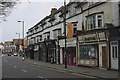
Chipstead Valley Road, Coulsdon - south side
Image: © David Kemp
Taken: 8 Apr 2015
0.07 miles
9
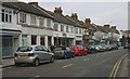
Coulsdon: Chipstead Valley Road
Looking northeast from the junction with Lion Green Road. Buses on Routes 166 and 434 have to pass along this crowded street, which often has vehicles parked on both sides of the road.
Image: © Dr Neil Clifton
Taken: 31 Dec 2014
0.07 miles
10
Crossroads in central Coulsdon, from Chipstead Valley Road
Image: © Christopher Hilton
Taken: 5 Jul 2015
0.07 miles