IMAGES TAKEN NEAR TO
Fairdene Road, COULSDON, CR5 1RA
Introduction
This page details the photographs taken nearby to Fairdene Road, CR5 1RA by members of the Geograph project.
The Geograph project started in 2005 with the aim of publishing, organising and preserving representative images for every square kilometre of Great Britain, Ireland and the Isle of Man.

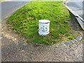
There are currently over 7.5m images from over14,400 individuals and you can help contribute to the project by visiting https://www.geograph.org.uk
Image Map
Images are licensed for reuse under creativecommons.org/licenses/by-sa/2.0
Notes
- Clicking on the map will re-center to the selected point.
- The higher the marker number, the further away the image location is from the centre of the postcode.
Image Listing (83 Images Found)
Images are licensed for reuse under creativecommons.org/licenses/by-sa/2.0
Image
Details
Distance
1
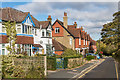
Downs Road
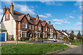
Edwardian villas on Downs Road, overlooking Farthing Downs, first appearing on the 1912 1:2,500 map, when the road was shown as Fanfare Road. Although the nearest house seems newer in style, it too first appears on that map.
Image: © Ian Capper
Taken: 27 Oct 2018
0.06 miles
2
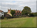
Houses in Downs Road, Coulsdon
These houses, dating from around 1900, have an enviable situation right on the edge of Farthing Downs.
Image: © Dr Neil Clifton
Taken: 18 Oct 2009
0.07 miles
3
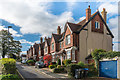
Downs Road
Edwardian villas on Downs Road, overlooking Farthing Downs, first appearing on the 1912 1:2,500 map, when the road was shown as Fanfare Road.
Image: © Ian Capper
Taken: 27 Oct 2018
0.07 miles
4
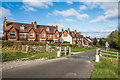
Downs Road
Edwardian villas on Downs Road, overlooking Farthing Downs, first appearing on the 1912 1:2,500 map, when the road was shown as Fanfare Road. In the foreground is cattle grid and gate marking the entrance to Farthing Downs. For a close up of one of the City of London Corporation posts by the entrance, see Image
Image: © Ian Capper
Taken: 27 Oct 2018
0.07 miles
5
Coulsdon: Coal Post A
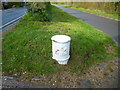
When walking from Coulsdon via the lane which runs along Farthing Downs, one encounters no less than ten coal posts. For the sake of clarity, I have allocated letters A to J to each of the posts; the letters are as follows:
A and B: These posts are not actually on Farthing Downs; they are (one each side) of a very short (c. 3 metres) piece of metalled road connecting Downs Road with the metalled lane that runs north to south along Farthing Downs. This lane,as far as I am aware, has no name, although at its southern end it connects with Ditches Lane.
The post in this picture is Post A, the northerly one of two across this short strip of road.
Image: © Dr Neil Clifton
Taken: 1 Apr 2017
0.07 miles
6
Farthing Downs: Coal Posts E and F
See Image
Image: © Dr Neil Clifton
Taken: 1 Apr 2017
0.07 miles
7
Downs Road
Edwardian villas on Downs Road, overlooking Farthing Downs, first appearing on the 1912 1:2,500 map, when the road was shown as Fanfare Road.
Image: © Ian Capper
Taken: 27 Oct 2018
0.07 miles
8
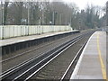
Coulsdon South station
Coulsdon South station was opened by the South Eastern Railway in October 1889. The line is on a steep gradient climbing towards Merstham Tunnel. It was originally called Coulsdon and Cane Hill, referring to the nearby Cane Hill Hospital - see http://en.wikipedia.org/wiki/Cane_Hill_Hospital Coulsdon South station is on the original Brighton Line, opened in two stages in 1841. To the west is the so-called Quarry Line, built by the London, Brighton & South Coast Railway as an avoiding line between Coulsdon North and Earlswood and which is still used by fast trains avoiding Redhill. It was opened on 8th November 1899.
Image: © Marathon
Taken: 27 Mar 2013
0.07 miles
9
Coulsdon: Coal Post B
The opposite side to A. See Image
Image: © Dr Neil Clifton
Taken: 1 Apr 2017
0.08 miles
10
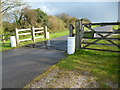
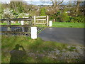
Farthing Downs: Coal Posts C, D, E, and F
These four posts are very close to A and B. They stand across the cattle grid at the northern end of the lane across Farthing Downs. In the picture,the nearest post is D, with C on the opposite side of the road. F and E are on the other side of the cattle grid, with E partly obscured. See Image
Image: © Dr Neil Clifton
Taken: 1 Apr 2017
0.08 miles