IMAGES TAKEN NEAR TO
The Netherlands, COULSDON, CR5 1NJ
Introduction
This page details the photographs taken nearby to The Netherlands, CR5 1NJ by members of the Geograph project.
The Geograph project started in 2005 with the aim of publishing, organising and preserving representative images for every square kilometre of Great Britain, Ireland and the Isle of Man.

There are currently over 7.5m images from over14,400 individuals and you can help contribute to the project by visiting https://www.geograph.org.uk
Image Map (Loading...)


Getting Data...Please wait
Leaflet Map data © OpenStreetMap
Images are licensed for reuse under creativecommons.org/licenses/by-sa/2.0
Notes
- Clicking on the map will re-center to the selected point.
- The higher the marker number, the further away the image location is from the centre of the postcode.
Image Listing (28 Images Found)
Images are licensed for reuse under creativecommons.org/licenses/by-sa/2.0
Image
Details
Distance
1
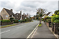
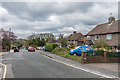
The Netherlands
Part of the 1930s "Dutch village" in this road, and the adjacent Wilhelmina Avenue and a small section of Woodplace Lane (see Image), designed by Dutch architect Wouter Hamdorff.
Image: © Ian Capper
Taken: 27 Oct 2018
0.11 miles
2
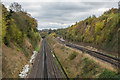
Brighton Lines
The Brighton Lines from Woodplace Lane Bridge. On the left is the original Brighton Line through Redhill, built in 1841, and on the right is the 1899 Quarry Line, bypassing Redhill. In the distance is the bridge where the latter crosses the former, with the Quarry Line running to the west of the original line until they meet again near Earlswood.
Image: © Ian Capper
Taken: 27 Oct 2018
0.11 miles
3
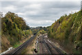
Brighton Lines
The Brighton Lines from Woodplace Lane Bridge. On the left is the original Brighton Line through Redhill, built in 1841, and on the right is the 1899 Quarry Line, bypassing Redhill. In the distance is the bridge where the latter crosses the former, with the Quarry Line running to the west of the original line until they meet again near Earlswood.
Image: © Ian Capper
Taken: 27 Oct 2018
0.12 miles
4
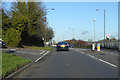
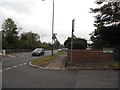
A23 Brighton Road
The left turn is Woodfield Hill, which is also the name of the bus stops on the main road.
Image: © Robin Webster
Taken: 18 Jan 2020
0.12 miles
5
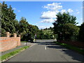
Woodplace Lane
Houses on Woodplace Lane, first marked on the 1935 1:2,500 map.
Image: © Ian Capper
Taken: 27 Oct 2018
0.13 miles
6
Woodfield Hill
This is the view looking down to the junction with Brighton Road (A23). Farthing Downs are on the far horizon.
Image: © Marathon
Taken: 24 Aug 2023
0.14 miles
7
Woodfield Hill at the junction of Brighton Road
Image: © David Howard
Taken: 29 Sep 2014
0.14 miles
8
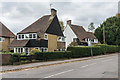
4 & 6 Woodplace Lane
Unusual "half" houses on Woodplace Lane, part of the 1930s "Dutch village" in this part of Woodplace Lane and the adjacent The Netherlands (see Image) and Wilhelmina Avenue, designed by Dutch architect Wouter Hamdorff.
Image: © Ian Capper
Taken: 27 Oct 2018
0.17 miles
9
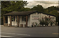
The Full Monty
Cafe on the A23 just outside Coulsdon town centre
Image: © Kurseong Carl
Taken: 29 Jun 2011
0.17 miles
10
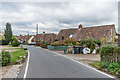
Woodplace Lane
Houses on Woodplace Lane, first marked on the 1935 1:2,500 map.
Image: © Ian Capper
Taken: 27 Oct 2018
0.17 miles