IMAGES TAKEN NEAR TO
Coulsdon Road, COULSDON, CR5 1EG
Introduction
This page details the photographs taken nearby to Coulsdon Road, CR5 1EG by members of the Geograph project.
The Geograph project started in 2005 with the aim of publishing, organising and preserving representative images for every square kilometre of Great Britain, Ireland and the Isle of Man.

There are currently over 7.5m images from over14,400 individuals and you can help contribute to the project by visiting https://www.geograph.org.uk
Image Map (Loading...)


Getting Data...Please wait
Leaflet Map data © OpenStreetMap
Images are licensed for reuse under creativecommons.org/licenses/by-sa/2.0
Notes
- Clicking on the map will re-center to the selected point.
- The higher the marker number, the further away the image location is from the centre of the postcode.
Image Listing (35 Images Found)
Images are licensed for reuse under creativecommons.org/licenses/by-sa/2.0
Image
Details
Distance
1
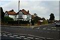
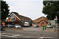
Junction of Keston Avenue and Coulsdon Road
Road junction near the centre of Old Coulsdon, Surrey.
Image: © Peter Trimming
Taken: 7 Nov 2012
0.02 miles
2
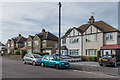
Court Avenue
1930s housing in Court Avenue. The road is marked on the 1935 1:2,500 map, with some development shown.
Image: © Ian Capper
Taken: 27 Oct 2018
0.08 miles
3
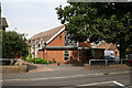
Surrey: Our Lady Help of Christians Roman Catholic Church, Old Coulsdon
Image: © Dr Neil Clifton
Taken: 2 Aug 2007
0.09 miles
4
St. Mary Help of Christians Roman Catholic Church, Coulsdon Road, Old Coulsdon
Image: © Dr Neil Clifton
Taken: 2 Aug 2007
0.09 miles
5
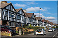
Taunton Lane
c1930s housing on Taunton Lane. These houses don't appear on the 1935 1:2,500 map but the adjacent shopping parade is, suggesting development in that decade. Taunton Lane itself is much older, being shown on 19th Century maps as a country lane leading to Taunton Farm.
Image: © Ian Capper
Taken: 12 Oct 2018
0.10 miles
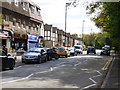
6
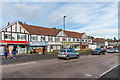
Taunton Lane shops
c1930s shopping parade in Taunton Lane, marked on the 1935 1:2,500 map. Taunton Lane itself is much older, being shown on 19th Century maps as a country lane leading to Taunton Farm.
Image: © Ian Capper
Taken: 12 Oct 2018
0.11 miles
8
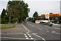
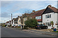
Shell garage, Coulsdon Road, Old Coulsdon
Looking northwards along Coulsdon Road. The road coming in from the left is Tollers Lane, while the woman with two black dogs is about to cross the end of Waddington Avenue. Lacey Green shops are out of view on the photographer's right.
Image: © Dr Neil Clifton
Taken: 2 Aug 2007
0.12 miles
9
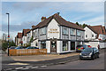
Glade Fisheries
Fish and Chip shop at the junction of The Glade and Taunton Lane.
Image: © Ian Capper
Taken: 12 Oct 2018
0.13 miles