IMAGES TAKEN NEAR TO
Ellis Road, COULSDON, CR5 1BZ
Introduction
This page details the photographs taken nearby to Ellis Road, CR5 1BZ by members of the Geograph project.
The Geograph project started in 2005 with the aim of publishing, organising and preserving representative images for every square kilometre of Great Britain, Ireland and the Isle of Man.

There are currently over 7.5m images from over14,400 individuals and you can help contribute to the project by visiting https://www.geograph.org.uk
Image Map (Loading...)


Getting Data...Please wait
Leaflet Map data © OpenStreetMap
Images are licensed for reuse under creativecommons.org/licenses/by-sa/2.0
Notes
- Clicking on the map will re-center to the selected point.
- The higher the marker number, the further away the image location is from the centre of the postcode.
Image Listing (14 Images Found)
Images are licensed for reuse under creativecommons.org/licenses/by-sa/2.0
Image
Details
Distance
1
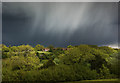
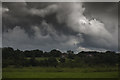
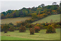
Sunshine & Showers
A view towards Lacey Green from the top of Farthing Downs
Image: © Kurseong Carl
Taken: 23 May 2013
0.09 miles
2
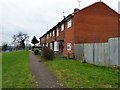
The Admiral's Walk
On the edge of one of the newer parts of Old Coulsdon.
Image: © Robin Webster
Taken: 24 Jan 2011
0.09 miles
3
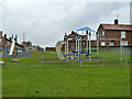
Play area at end of Ellis Road, Coulsdon
Image: © Robin Webster
Taken: 24 Jan 2011
0.10 miles
4
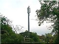
Telecommunications Mast, Old Coulsdon
Image: © Alex McGregor
Taken: 21 Jun 2011
0.11 miles
6
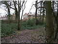
Woodland south of Weston Close, Coulsdon
The wood is part of the Happy Valley open space.
Image: © Robin Webster
Taken: 24 Jan 2011
0.15 miles
7
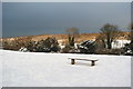
Bench With a View
With freezing temperatures, and rising winds (and dark clouds which, amazingly, didn't drop anything), nobody took the option of a seated view over Happy Valley.
Image: © Peter Trimming
Taken: 7 Jan 2010
0.20 miles
8
Sitting With The Dog
This is Happy Valley, on the London Loop path.
There are Happy Valleys all over the place. The most famous is a racecourse in Hong Kong, but where did the name originate?
Image: © Des Blenkinsopp
Taken: 2 Apr 2013
0.21 miles
9
Happy Valley
A c.250 acre downland and woodland open space owned and managed by Croydon Council, bought in 1937 by the then Coulsdon and Purley Urban District Council with funding shared equally with the London County Council and Surrey County Council.
Image: © Ian Capper
Taken: 29 Oct 2016
0.22 miles
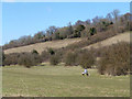
10
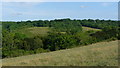
View Across Happy Valley, Surrey
Looking across to a clearing in the woods, and a ring of trees within the clearing. The ring of trees can be seen more clearly during the winter months.
Image: © Peter Trimming
Taken: 4 Jul 2009
0.22 miles