IMAGES TAKEN NEAR TO
New Road, MITCHAM, CR4 4JN
Introduction
This page details the photographs taken nearby to New Road, CR4 4JN by members of the Geograph project.
The Geograph project started in 2005 with the aim of publishing, organising and preserving representative images for every square kilometre of Great Britain, Ireland and the Isle of Man.

There are currently over 7.5m images from over14,400 individuals and you can help contribute to the project by visiting https://www.geograph.org.uk
Image Map
Images are licensed for reuse under creativecommons.org/licenses/by-sa/2.0
Notes
- Clicking on the map will re-center to the selected point.
- The higher the marker number, the further away the image location is from the centre of the postcode.
Image Listing (83 Images Found)
Images are licensed for reuse under creativecommons.org/licenses/by-sa/2.0
Image
Details
Distance
1
The Apostolic Church - Hackbridge Assembly
This is across the road from All Saints church.
Image: © Robin Webster
Taken: 1 Apr 2012
0.07 miles
2
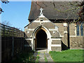
Porch, Hackbridge and Beddington Corner church
All Saints.
Image: © Robin Webster
Taken: 1 Apr 2012
0.08 miles
4
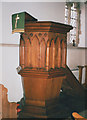
All Saints church, Hackbridge: pulpit
This unique wooden pulpit was allegedly carved by German Prisoners-of-War and incorporates the shape of a gun shell at each corner.
Image: © Stephen Craven
Taken: 22 Sep 2003
0.10 miles
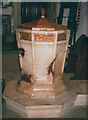
5
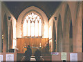
All Saints church, Hackbridge: interior
The parish church of Hackbridge and Beddington Corner was built in 1931. The architect was H.P. Burke-Downing, whose other church in the area is St Barnabas Image, but this one is not listed.
Image: © Stephen Craven
Taken: 22 Sep 2003
0.10 miles
6
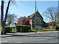
Hackbridge and Beddington Corner church
All Saints.
Image: © Robin Webster
Taken: 1 Apr 2012
0.10 miles
7
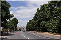
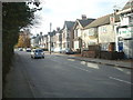
Beddington Corner
London Road, looking north.
Image: © Peter Trimming
Taken: 23 Jul 2018
0.12 miles
8
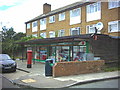
Seymour Road Post Office.
Like so many now, this is more a supermarket than a post office.
Image: © Noel Foster
Taken: 6 Jul 2005
0.13 miles
10
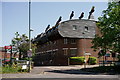
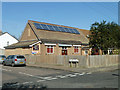
BedZED
Beddington Zero Energy Development (BedZED) is an environmentally friendly housing development in Hackbridge. It is in the London Borough of Sutton, 2 miles north-east of the town of Sutton itself. Designed to create zero carbon emissions, it was the first large scale community to do so.
Image: © Peter Trimming
Taken: 22 Apr 2020
0.13 miles