IMAGES TAKEN NEAR TO
Ravensbury Grove, MITCHAM, CR4 4DL
Introduction
This page details the photographs taken nearby to Ravensbury Grove, CR4 4DL by members of the Geograph project.
The Geograph project started in 2005 with the aim of publishing, organising and preserving representative images for every square kilometre of Great Britain, Ireland and the Isle of Man.

There are currently over 7.5m images from over14,400 individuals and you can help contribute to the project by visiting https://www.geograph.org.uk
Image Map
Images are licensed for reuse under creativecommons.org/licenses/by-sa/2.0
Notes
- Clicking on the map will re-center to the selected point.
- The higher the marker number, the further away the image location is from the centre of the postcode.
Image Listing (80 Images Found)
Images are licensed for reuse under creativecommons.org/licenses/by-sa/2.0
Image
Details
Distance
1
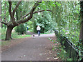
The Wandle Trail through Ravensbury Park
A cycling and walking route along the river bank offering a traffic-free route between the busy A24 and A217 roads.
Image: © Stephen Craven
Taken: 26 Aug 2008
0.05 miles
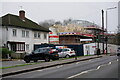
2
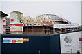
Morden
Part of the massive Clarion Housing development at the edge of Ravensbury Park and close to Morden Hall Park.
Ravensbury is part of the £1bn Merton Regeneration Project, creating 2,800 homes; replacing 1,000 existing homes and building 1,800 new homes.
Image: © Peter Trimming
Taken: 29 Dec 2024
0.07 miles
4
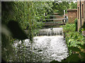
Weir at Ravensbury Mill
There was a water mill on or near this site on the river Wandle since medieval times.
Image: © Stephen Craven
Taken: 26 Aug 2008
0.07 miles
5
Morden
Part of the massive Clarion Housing development at the edge of Ravensbury Park and close to Morden Hall Park.
Ravensbury is part of the £1bn Merton Regeneration Project, creating 2,800 homes; replacing 1,000 existing homes and building 1,800 new homes.
Image: © Peter Trimming
Taken: 29 Dec 2024
0.08 miles
6
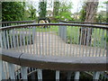
Bridge over a branch of the Wandle in Ravensbury Park
Ravensbury Park was at one time part of the Ravensbury Estate. The estate was eventually broken up in 1929 and much was developed for housing, except for the present Ravensbury Park. This was bought jointly by Mitcham Council and Merton & Morden Council for £5,310. It was opened to the public in May 1930. The Wandle and its branches are the main feature of the park. This bridge is over a branch of the Wandle which leaves the main channel of the Wandle downriver from London Road (A217) within the park, and rejoins the Wandle just beyond Morden Road in Morden Hall Park. A couple of old mill stones can just be seen beyond the bridge.
Image: © Marathon
Taken: 2 May 2012
0.08 miles

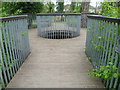
8
Old mill stones and footbridge in Ravensbury Park
Ravensbury Park was at one time part of the Ravensbury Estate. The estate was eventually broken up in 1929 and much was developed for housing, except for the present Ravensbury Park. This was bought jointly by Mitcham Council and Merton & Morden Council for £5,310. It was opened to the public in May 1930. The Wandle and its branches are the main feature of the park. This bridge is over a branch of the Wandle which leaves the main channel of the Wandle downriver from London Road (A217) within the park, and rejoins the Wandle just beyond Morden Road in Morden Hall Park. A couple of old mill stones can be seen beyond the bridge. These were possibly from Ravensbury Mill which is just to the right, out of the picture.
Image: © Marathon
Taken: 2 May 2012
0.08 miles
9
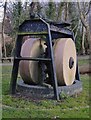
Millstones, Ravensbury Park
Relics of the Wandle's industrial past, now displayed close to the former Ravensbury Mill site (not far from the Surrey Arms).
Image: © Stefan Czapski
Taken: 14 Mar 2013
0.08 miles