IMAGES TAKEN NEAR TO
Riverside Drive, MITCHAM, CR4 4BW
Introduction
This page details the photographs taken nearby to Riverside Drive, CR4 4BW by members of the Geograph project.
The Geograph project started in 2005 with the aim of publishing, organising and preserving representative images for every square kilometre of Great Britain, Ireland and the Isle of Man.

There are currently over 7.5m images from over14,400 individuals and you can help contribute to the project by visiting https://www.geograph.org.uk
Image Map
Images are licensed for reuse under creativecommons.org/licenses/by-sa/2.0
Notes
- Clicking on the map will re-center to the selected point.
- The higher the marker number, the further away the image location is from the centre of the postcode.
Image Listing (104 Images Found)
Images are licensed for reuse under creativecommons.org/licenses/by-sa/2.0
Image
Details
Distance
1
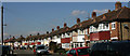
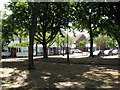
Riverside Drive, Mitcham
A view of classic suburbia in Mitcham.
Image: © Hugh Chevallier
Taken: 23 Mar 2011
0.04 miles
2
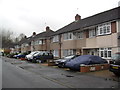
Riverside Drive
1930s houses in Mitcham.
Image: © Burgess Von Thunen
Taken: 27 Nov 2012
0.06 miles
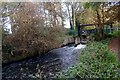
3

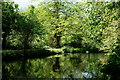
River Wandle
Little grebe, one of a pair in the Watermeads reserve.
Image: © Peter Trimming
Taken: 5 May 2022
0.07 miles
5
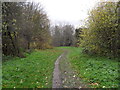
Mitcham
A path near the River Wandle.
Image: © Burgess Von Thunen
Taken: 27 Nov 2012
0.08 miles
6

River Wandle
Moorhen on the nest and little grebe, one of a pair, in the Watermeads reserve.
Image: © Peter Trimming
Taken: 5 May 2022
0.08 miles
7
Mitcham: Jessop Place
High-class development close to Mitcham tram stop. The development's name has no connection with the well-known photographic firm, but relates to the talented civil engineer William Jessop, who laid out the trackbed for the Surrey Iron Railway, which once ran where the electric tramline is now.
Image: © Dr Neil Clifton
Taken: 24 May 2011
0.09 miles
8
River Wandle
Bennett's Hole Nature Reserve, Mitcham.
Image: © Peter Trimming
Taken: 22 Apr 2020
0.11 miles
9
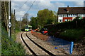
Approaching Mitcham Tram Stop
A tram arriving from Croydon. To the right of the existing track, work is well under way to add a second track, between Mitcham and Mitcham Junction, to increase capacity. This work is scheduled to be completed by June 2012.
Image: © Peter Trimming
Taken: 26 Apr 2012
0.11 miles
10
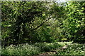
Bennett's Hole
A local nature reserve, on the edge of Mitcham, close to the River Wandle. To the left of the path is an ash tree; the branch coming out at forty-five degrees, and overhanging the path, has died (possibly ash die-back) and a pinned notice has advised the intention to remove this branch.
Image: © Peter Trimming
Taken: 22 Apr 2020
0.12 miles