IMAGES TAKEN NEAR TO
Pharaoh Close, MITCHAM, CR4 4AP
Introduction
This page details the photographs taken nearby to Pharaoh Close, CR4 4AP by members of the Geograph project.
The Geograph project started in 2005 with the aim of publishing, organising and preserving representative images for every square kilometre of Great Britain, Ireland and the Isle of Man.

There are currently over 7.5m images from over14,400 individuals and you can help contribute to the project by visiting https://www.geograph.org.uk
Image Map
Images are licensed for reuse under creativecommons.org/licenses/by-sa/2.0
Notes
- Clicking on the map will re-center to the selected point.
- The higher the marker number, the further away the image location is from the centre of the postcode.
Image Listing (59 Images Found)
Images are licensed for reuse under creativecommons.org/licenses/by-sa/2.0
Image
Details
Distance
1
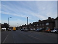
Middleton Road, St Helier
St Helier is mainly a huge council estate all with roughly similar houses like these.
Image: © David Howard
Taken: 24 Mar 2014
0.04 miles
3

Budge Lane, Beddington Corner
The estate is on the site of the old Wandle Valley Hospital
Image: © David Howard
Taken: 24 Mar 2014
0.09 miles
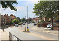
4

Budge Lane, Beddington Corner
The estate is on the site of the old Wandle Valley Hospital
Image: © David Howard
Taken: 24 Mar 2014
0.09 miles
5
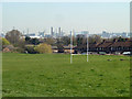
View from Poulter Park
Looking towards the twin chimneys of the former Croydon power station.
Image: © Robin Webster
Taken: 28 Mar 2012
0.09 miles
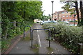
6
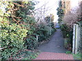
Wandle Trail near St Helier
This path forms part of the Wandle Trail, and is also on the route of National Cycle Network route 20.
Image: © Malc McDonald
Taken: 4 Jan 2020
0.09 miles
7

Parking spaces on Budge Lane, Beddington Corner
Image: © David Howard
Taken: 24 Mar 2014
0.10 miles
9
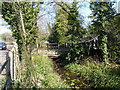
River Wandle backwater
Probably approximating to the natural course, the main flow now passes through the site of an old mill to the right. Looking downstream.
Image: © Robin Webster
Taken: 28 Mar 2012
0.11 miles
10
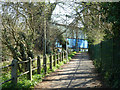
Footpath along River Wandle
To the left is the bypass for an old mill further left. It may however have been the mill race or other process flow for a leather mill. There was more than one mill at this location over the years.
Image: © Robin Webster
Taken: 28 Mar 2012
0.11 miles