IMAGES TAKEN NEAR TO
Hallowell Close, MITCHAM, CR4 2QD
Introduction
This page details the photographs taken nearby to Hallowell Close, CR4 2QD by members of the Geograph project.
The Geograph project started in 2005 with the aim of publishing, organising and preserving representative images for every square kilometre of Great Britain, Ireland and the Isle of Man.

There are currently over 7.5m images from over14,400 individuals and you can help contribute to the project by visiting https://www.geograph.org.uk
Image Map
Images are licensed for reuse under creativecommons.org/licenses/by-sa/2.0
Notes
- Clicking on the map will re-center to the selected point.
- The higher the marker number, the further away the image location is from the centre of the postcode.
Image Listing (50 Images Found)
Images are licensed for reuse under creativecommons.org/licenses/by-sa/2.0
Image
Details
Distance
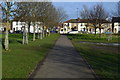
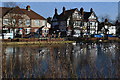
4
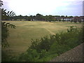
Three Kings Piece from Commonside East railway bridge.
More of Mitcham Common, this, between Commonside East and Commonside West (A236) takes its name from the Three Kings pub. Or the other way round.
Image: © Noel Foster
Taken: 28 Jun 2005
0.10 miles
5
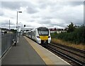
Mitcham Eastfields Railway Station
Thameslink Class 700, No. 700055 departing for Sutton.
Image: © JThomas
Taken: 25 Jul 2022
0.13 miles