IMAGES TAKEN NEAR TO
Lammas Avenue, MITCHAM, CR4 2LY
Introduction
This page details the photographs taken nearby to Lammas Avenue, CR4 2LY by members of the Geograph project.
The Geograph project started in 2005 with the aim of publishing, organising and preserving representative images for every square kilometre of Great Britain, Ireland and the Isle of Man.

There are currently over 7.5m images from over14,400 individuals and you can help contribute to the project by visiting https://www.geograph.org.uk
Image Map
Images are licensed for reuse under creativecommons.org/licenses/by-sa/2.0
Notes
- Clicking on the map will re-center to the selected point.
- The higher the marker number, the further away the image location is from the centre of the postcode.
Image Listing (81 Images Found)
Images are licensed for reuse under creativecommons.org/licenses/by-sa/2.0
Image
Details
Distance
3
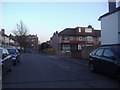
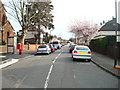
St. Marks Road, Mitcham
St. Mark's church is beyond the large tree.
Image: © Robin Webster
Taken: 1 Apr 2012
0.08 miles
4
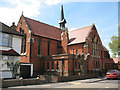
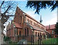
St Mark's church, Mitcham
This Anglican parish church on St Mark's Road was completed in 1910. It was reordered c.1980 to make half of it a community centre with the remaining half rearranged for worship.
Image: © Stephen Craven
Taken: 10 May 2010
0.09 miles
5
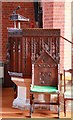
St Mark, St Mark's Road, Mitcham - Pulpit
Image: © John Salmon
Taken: 15 Feb 2012
0.09 miles
6
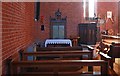
St Mark, St Mark's Road, Mitcham - North chapel
Image: © John Salmon
Taken: 15 Feb 2012
0.10 miles
9
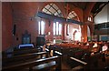
St Mark, St Mark's Road, Mitcham - Interior
Image: © John Salmon
Taken: 15 Feb 2012
0.10 miles
10
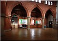
St Mark, St Mark's Road, Mitcham - Arcade
Image: © John Salmon
Taken: 15 Feb 2012
0.10 miles