IMAGES TAKEN NEAR TO
Graham Road, MITCHAM, CR4 2HB
Introduction
This page details the photographs taken nearby to Graham Road, CR4 2HB by members of the Geograph project.
The Geograph project started in 2005 with the aim of publishing, organising and preserving representative images for every square kilometre of Great Britain, Ireland and the Isle of Man.

There are currently over 7.5m images from over14,400 individuals and you can help contribute to the project by visiting https://www.geograph.org.uk
Image Map (Loading...)


Getting Data...Please wait
Leaflet Map data © OpenStreetMap
Images are licensed for reuse under creativecommons.org/licenses/by-sa/2.0
Notes
- Clicking on the map will re-center to the selected point.
- The higher the marker number, the further away the image location is from the centre of the postcode.
Image Listing (59 Images Found)
Images are licensed for reuse under creativecommons.org/licenses/by-sa/2.0
Image
Details
Distance
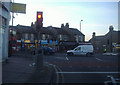
3

1-5 Streatham Road
A pair of three-bay three-storey C18th houses with later wings at each end. Grade II listed.
Image: © Stephen Richards
Taken: 22 Mar 2015
0.08 miles
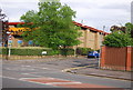
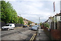
5
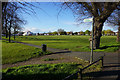
Graham Road
Part of the large area of suburban housing surrounding Streatham.
Image: © Bill Boaden
Taken: 30 Apr 2016
0.09 miles
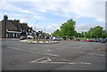
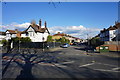
6
Junction of Locks Lane and London Road, Mitcham
Image: © David Howard
Taken: 31 Jan 2011
0.09 miles
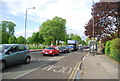
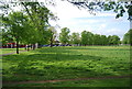
8
Public footpath across Figge's Marsh
A circus has set up on the other side of the open space.
Image: © Bill Boaden
Taken: 30 Apr 2016
0.12 miles