IMAGES TAKEN NEAR TO
Pearson Way, MITCHAM, CR4 2GF
Introduction
This page details the photographs taken nearby to Pearson Way, CR4 2GF by members of the Geograph project.
The Geograph project started in 2005 with the aim of publishing, organising and preserving representative images for every square kilometre of Great Britain, Ireland and the Isle of Man.

There are currently over 7.5m images from over14,400 individuals and you can help contribute to the project by visiting https://www.geograph.org.uk
Image Map (Loading...)


Getting Data...Please wait
Leaflet Map data © OpenStreetMap
Images are licensed for reuse under creativecommons.org/licenses/by-sa/2.0
Notes
- Clicking on the map will re-center to the selected point.
- The higher the marker number, the further away the image location is from the centre of the postcode.
Image Listing (38 Images Found)
Images are licensed for reuse under creativecommons.org/licenses/by-sa/2.0
Image
Details
Distance
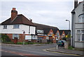
1
Old footbridge at Mitcham Eastfields
The footbridge is at the north end of the station but does not connect with the platform and obviously pre-dates the construction of the station in 2008. It connects Rialto Road and Grove Road.
Image: © Stephen Craven
Taken: 10 May 2010
0.12 miles
3
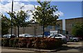
Mitcham Industrial Estate: Streatham Road 4
Image: © Michael Garlick
Taken: 20 Sep 2013
0.17 miles
6

Mitcham Industrial Estate: Streatham Road 1
Image: © Michael Garlick
Taken: 20 Sep 2013
0.18 miles
7

Mitcham Industrial Estate: Streatham Road 2
Image: © Michael Garlick
Taken: 20 Sep 2013
0.18 miles
8
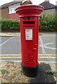
Elizabeth II postbox on Eastfields Road, Mitcham
Postbox No. CR4 61.
See Image] for context.
Image: © JThomas
Taken: 25 Jul 2022
0.19 miles
9
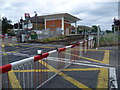
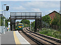
Mitcham Eastfields station
The Peckham Rye to Sutton line via Streatham opened in 1868. There was a very long stretch without a station between Streatham and Mitcham Junction, and an even longer journey without a station for trains coming from Balham to Mitcham Junction. Where Mitcham Eastfields is now, at Eastfields Road level crossing, was poorly served by public transport. Mitcham Junction, and Mitcham Tramlink stop were both over a mile away. Mitcham Eastfields opened on 2nd June 2008. The platforms are arranged so that each is situated beyond the level crossing in the direction of travel, allowing the crossing to be reopened while trains are stopped at the station and minimising the disruption to road traffic.
Image: © Marathon
Taken: 6 Jun 2012
0.20 miles
10
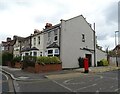
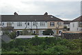
Houses on Eastfields Road, Mitcham
Showing position of Postbox No. CR4 61.
See Image] for postbox.
Image: © JThomas
Taken: 25 Jul 2022
0.20 miles