IMAGES TAKEN NEAR TO
Caithness Road, MITCHAM, CR4 2EY
Introduction
This page details the photographs taken nearby to Caithness Road, CR4 2EY by members of the Geograph project.
The Geograph project started in 2005 with the aim of publishing, organising and preserving representative images for every square kilometre of Great Britain, Ireland and the Isle of Man.

There are currently over 7.5m images from over14,400 individuals and you can help contribute to the project by visiting https://www.geograph.org.uk
Image Map (Loading...)


Getting Data...Please wait
Leaflet Map data © OpenStreetMap
Images are licensed for reuse under creativecommons.org/licenses/by-sa/2.0
Notes
- Clicking on the map will re-center to the selected point.
- The higher the marker number, the further away the image location is from the centre of the postcode.
Image Listing (18 Images Found)
Images are licensed for reuse under creativecommons.org/licenses/by-sa/2.0
Image
Details
Distance
1
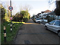
Ridge Road, near Streatham
Ridge Road is a minor residential road near Streatham, in the suburbs of south London. The sign indicates that a 20mph speed limit applies.
This image was taken on a January day when the sun was low in the sky, casting long shadows.
Image: © Malc McDonald
Taken: 4 Jan 2020
0.07 miles
2
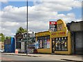
Retail premises, Mitcham Lane, SW16
These face north-west, just north of the railway bridge. It looks as if only one unit is still occupied, with the whole row about to be redeveloped.
Image: © Stefan Czapski
Taken: 3 Jun 2015
0.09 miles
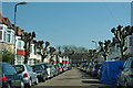
3
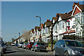
Melrose Avenue
One of several residential streets off A216 Streatham Road.
Image: © Robin Webster
Taken: 1 Apr 2012
0.09 miles
4
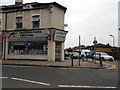
Decorators Centre on the corner of Streatham Road and Links Road
Image: © David Howard
Taken: 29 Sep 2013
0.09 miles
5
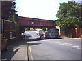
Railway Bridge over Streatham Road.
It would be more accurate to say that the road goes under the bridge.
Image: © Noel Foster
Taken: 28 Jun 2005
0.11 miles
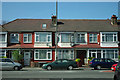
6
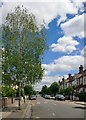
Caithness Road
One of several residential streets off A216 Streatham Road.
Image: © Robin Webster
Taken: 1 Apr 2012
0.14 miles
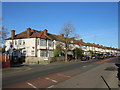
7
Houses on Streatham Road
Opposite the end of Melrose Avenue.
Image: © Robin Webster
Taken: 1 Apr 2012
0.15 miles
8
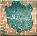
Old Boundary Marker on Roe Bridge
County Boundary Marker by the A216, in parish of Streatham (Lambeth District), on the southeast parapet of Roe Bridge on the A216 Mitcham Road / Streatham Road SW16.
surveyed
Milestone Society National ID: SY_LOSY02cb
Image: © Milestone Society
Taken: Unknown
0.19 miles
9
Links Road, SW17
View eastwards. The turning on the left a little way ahead is Jersey Road.
Image: © Stefan Czapski
Taken: 3 Jun 2015
0.19 miles
10
Streatham Road, near Mitcham
Streatham Road forms part of the short A216 road in the south London suburbs.
Image: © Malc McDonald
Taken: 4 Jan 2020
0.20 miles