IMAGES TAKEN NEAR TO
Framfield Road, MITCHAM, CR4 2AL
Introduction
This page details the photographs taken nearby to Framfield Road, CR4 2AL by members of the Geograph project.
The Geograph project started in 2005 with the aim of publishing, organising and preserving representative images for every square kilometre of Great Britain, Ireland and the Isle of Man.

There are currently over 7.5m images from over14,400 individuals and you can help contribute to the project by visiting https://www.geograph.org.uk
Image Map
Images are licensed for reuse under creativecommons.org/licenses/by-sa/2.0
Notes
- Clicking on the map will re-center to the selected point.
- The higher the marker number, the further away the image location is from the centre of the postcode.
Image Listing (83 Images Found)
Images are licensed for reuse under creativecommons.org/licenses/by-sa/2.0
Image
Details
Distance
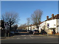
2
Manship Road, Mitcham
Manship Road is a residential road in Mitcham, in the suburbs of south London. Houses overlook Figge's Marsh.
This image was taken early in the afternoon on a day in early January. The sun was low in the sky, casting long shadows, and the trees were bare.
Image: © Malc McDonald
Taken: 4 Jan 2020
0.09 miles
3
Queen Elizabeth II Field
Part of a redesignation of certain open spaces to commemorate the Diamond Jubilee of Elizabeth II in 2012.
Image: © Bill Boaden
Taken: 30 Apr 2016
0.10 miles
4
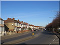
Streatham Road, near Mitcham
Streatham Road forms part of the short A216 road in the south London suburbs.
This image was taken on a day in early January when the sun was low in the sky, casting long shadows.
Image: © Malc McDonald
Taken: 4 Jan 2020
0.11 miles
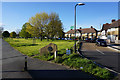
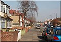
5
St James' Road, near Mitcham
St James' Road is a residential road in the south London suburbs.
This image was taken on a sunny day in early January. The trees were bare, while the sun was low in the sky casting long shadows.
Image: © Malc McDonald
Taken: 4 Jan 2020
0.11 miles
8
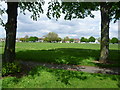
Figge's Marsh
Despite suggestions that this was formerly Pigs’ Marsh, Figge's Marsh was in fact named after William Figge, who held the land from 1357. It was common land and had been vested in the Board of Mitcham Common Conservators since 1891. It was taken over by Mitcham Urban District Council under a private Act in 1923. The area was mostly built up in the mid-20th century, much of it with council housing. Figge's Marsh was formerly home to Tooting Graveney FC (which is now Tooting and Mitcham FC) and Mitcham Rugby Club. The houses on the far side are in Manship Road. Figge's Marsh is completely flat and very largely featureless.
Image: © Marathon
Taken: 16 May 2012
0.12 miles
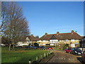
9
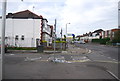
Manship Rd
At the junction with the A216.
Image: © N Chadwick
Taken: 11 May 2013
0.12 miles
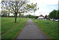
10
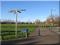
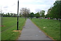
Figge's Marsh, Mitcham
A pavement leading to a path across Figge's Marsh in Mitcham, in the suburbs of south London.
This image was taken in the early afternoon of a sunny day in early January. The sun was low in the sky, casting long shadows.
Image: © Malc McDonald
Taken: 4 Jan 2020
0.12 miles