IMAGES TAKEN NEAR TO
Shropshire Close, MITCHAM, CR4 1XX
Introduction
This page details the photographs taken nearby to Shropshire Close, CR4 1XX by members of the Geograph project.
The Geograph project started in 2005 with the aim of publishing, organising and preserving representative images for every square kilometre of Great Britain, Ireland and the Isle of Man.

There are currently over 7.5m images from over14,400 individuals and you can help contribute to the project by visiting https://www.geograph.org.uk
Image Map (Loading...)


Getting Data...Please wait
Leaflet Map data © OpenStreetMap
Images are licensed for reuse under creativecommons.org/licenses/by-sa/2.0
Notes
- Clicking on the map will re-center to the selected point.
- The higher the marker number, the further away the image location is from the centre of the postcode.
Image Listing (21 Images Found)
Images are licensed for reuse under creativecommons.org/licenses/by-sa/2.0
Image
Details
Distance
2
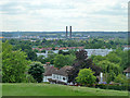
View south from Pollards Hill
Looking towards the chimneys of the former Croydon power station, a site used by the Ikea store.
Image: © Robin Webster
Taken: 1 Jul 2011
0.05 miles
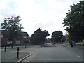
3

Montgomery Close, Mitcham
Looking towards Monmouth Close
Image: © David Howard
Taken: 22 Jun 2014
0.06 miles
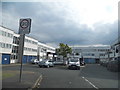
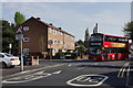
6
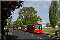
Pollards Hill
Buses at the bus stand.
Image: © Peter Trimming
Taken: 12 Apr 2020
0.11 miles
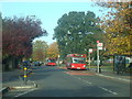
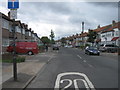
8
Approaching Pollards Hill
Service 60 bus, at the junction of Galpin's Road with South Lodge Avenue.
Image: © Peter Trimming
Taken: 12 Apr 2020
0.12 miles
9
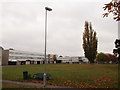
Humdard Centre, Thornton Heath
Children's Centre, on Mayfield Recreational Ground access road.
Image: © David Anstiss
Taken: 30 Oct 2011
0.12 miles
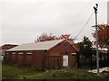
10
Housing on South Lodge Avenue
These blocks of social housing are managed by Moat Housing.
In the foreground is Donnelly Green.
Image: © David Anstiss
Taken: 30 Oct 2011
0.13 miles