IMAGES TAKEN NEAR TO
Brecon Close, MITCHAM, CR4 1XB
Introduction
This page details the photographs taken nearby to Brecon Close, CR4 1XB by members of the Geograph project.
The Geograph project started in 2005 with the aim of publishing, organising and preserving representative images for every square kilometre of Great Britain, Ireland and the Isle of Man.

There are currently over 7.5m images from over14,400 individuals and you can help contribute to the project by visiting https://www.geograph.org.uk
Image Map (Loading...)


Getting Data...Please wait
Leaflet Map data © OpenStreetMap
Images are licensed for reuse under creativecommons.org/licenses/by-sa/2.0
Notes
- Clicking on the map will re-center to the selected point.
- The higher the marker number, the further away the image location is from the centre of the postcode.
Image Listing (46 Images Found)
Images are licensed for reuse under creativecommons.org/licenses/by-sa/2.0
Image
Details
Distance
1
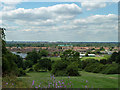
View south-west from Pollards Hill
This is a fine viewpoint for many directions. This view is towards Mitcham Common. The tower cranes with a green sheeted building are on the near edge of the common, which extends left and right. It appears as woodland in this oblique view, although it has large areas of grassland. The white cluster of buildings in the distance is St. Helier Hospital.
Image: © Robin Webster
Taken: 1 Jul 2011
0.07 miles
2

Pollards Hill Library
Modern library building on South Lodge Avenue.
Image: © David Anstiss
Taken: 30 Oct 2011
0.07 miles
3
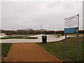
Pollards Hill Skate Park
Skate and BMX park in the large recreational ground beside Recreation Way below Pollards Hill.
In the background, is a set of Adult outdoor gym equipment.
In the far background, is Harris Academy Merton
Image: © David Anstiss
Taken: 30 Oct 2011
0.07 miles
4
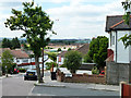
View south-west from Ena Road
Ena Road drops down the hill at a signed 17% gradient. Mitcham Common shows as a wooded area in the middle distance.
Image: © Robin Webster
Taken: 1 Jul 2011
0.08 miles

6
Pollards Hill
Roundabout at the western end of South Lodge Avenue.
Image: © Peter Trimming
Taken: 12 Apr 2020
0.08 miles
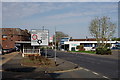
7

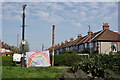
Roundabout in Pollards Hill
South Lodge Avenue from Thornton Heath leads to the junction.
On the left, Chestnut Grove (passes some shops) towards Commonside East.
Also, Sherwood Park Road leads to Manor Road.
On the right, Wide Way leads to Rowan Road, and Recreation Way leads back to South Lodge Avenue.
Image: © David Anstiss
Taken: 30 Oct 2011
0.09 miles
8
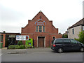
Pollards Hill Baptist Church
On Wide Way. We are just in the eastern fringes of the London Borough of Merton here.
Image: © Dr Neil Clifton
Taken: 21 May 2012
0.09 miles
9

Pollards Hill Baptist Church
On Wide Way.
Image: © David Anstiss
Taken: 30 Oct 2011
0.10 miles
10
Pollards Hill
View towards the library.
Image: © Peter Trimming
Taken: 12 Apr 2020
0.10 miles