IMAGES TAKEN NEAR TO
Park View Road, CATERHAM, CR3 7DL
Introduction
This page details the photographs taken nearby to Park View Road, CR3 7DL by members of the Geograph project.
The Geograph project started in 2005 with the aim of publishing, organising and preserving representative images for every square kilometre of Great Britain, Ireland and the Isle of Man.

There are currently over 7.5m images from over14,400 individuals and you can help contribute to the project by visiting https://www.geograph.org.uk
Image Map (Loading...)


Getting Data...Please wait
Leaflet Map data © OpenStreetMap
Images are licensed for reuse under creativecommons.org/licenses/by-sa/2.0
Notes
- Clicking on the map will re-center to the selected point.
- The higher the marker number, the further away the image location is from the centre of the postcode.
Image Listing (7 Images Found)
Images are licensed for reuse under creativecommons.org/licenses/by-sa/2.0
Image
Details
Distance
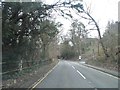
2
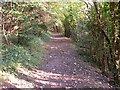
Path North of Woldingham
The path runs between Woldingham Garden Village and Woldingham. This view is South East, towards Woldingham, in a wood with many yew trees.
Image: © Richard Mascall
Taken: 17 Sep 2005
0.11 miles
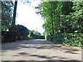
5
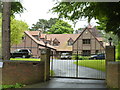
Woldingham: The Grange, Southdown Road
Image: © Dr Neil Clifton
Taken: 3 Jul 2012
0.18 miles
7
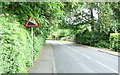
Station Road - Steep Hill 8%
Station Road, Woldingham. 8% steep hill down sign.
Image: © Adam Morse
Taken: 11 Jun 2009
0.22 miles