IMAGES TAKEN NEAR TO
Station Road, CATERHAM, CR3 7DD
Introduction
This page details the photographs taken nearby to Station Road, CR3 7DD by members of the Geograph project.
The Geograph project started in 2005 with the aim of publishing, organising and preserving representative images for every square kilometre of Great Britain, Ireland and the Isle of Man.

There are currently over 7.5m images from over14,400 individuals and you can help contribute to the project by visiting https://www.geograph.org.uk
Image Map
Images are licensed for reuse under creativecommons.org/licenses/by-sa/2.0
Notes
- Clicking on the map will re-center to the selected point.
- The higher the marker number, the further away the image location is from the centre of the postcode.
Image Listing (48 Images Found)
Images are licensed for reuse under creativecommons.org/licenses/by-sa/2.0
Image
Details
Distance
1
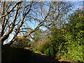
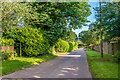
Long Hill, Woldingham
There is a notice near this point saying "Private street, Unmade single track ahead, Unsuitable for motor vehicles." This is just past the primary school.
Ian Nairn in 'The Buildings of England: Surrey' describes Woldingham: "This tiny downland hamlet SE of Caterham has gradually become a very leafy suburb. The parish is full of steep-sided valleys and the houses are hidden away in these, usually drowned in trees - an object lesson to the brutally expanded Warlingham, next door."
Image: © Marathon
Taken: 2 Mar 2023
0.04 miles
2
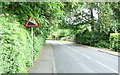
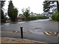
Station Road - Steep Hill 8%
Station Road, Woldingham. 8% steep hill down sign.
Image: © Adam Morse
Taken: 11 Jun 2009
0.04 miles
3
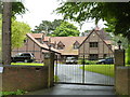
Woldingham: The Grange, Southdown Road
Image: © Dr Neil Clifton
Taken: 3 Jul 2012
0.08 miles
8
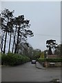
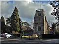
St Paul's church, Woldingham: village memorial (2)
See Image for details. This view is looking away from the church and out to the road.
Image: © Stephen Craven
Taken: 19 Feb 2015
0.13 miles
9
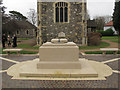
St Paul's church, Woldingham: village memorial (1)
This stone memorial was designed by Liam O'Connor and erected in 2014. It replaced the earlier war memorial inside the church Image and the scope was extended to include the names of those from the village who have died in more recent military or public service. See Image for a previous view.
The memorial has "we will remember them" carved on this front face; the list of names on the rear; and at the ends the badges of the Middlesex Regiment and the West Nova Scotia Regiment (Canada). I can supply close-up photos of these on request.
Image: © Stephen Craven
Taken: 19 Feb 2015
0.13 miles
10
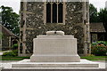
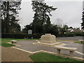
Woldingham War Memorial
The stone memorial in front of St Paul's Church in Woldingham was unveiled in October 2014.
The first inscribed date is that of a sailor killed in one of the earliest submarine disasters in 1912, while the most recent date is 1976.
Previously the village's only memorial had been a wooden plaque originally hung in the old church of St Paul.
The new memorial has been designed by architect Liam O'Connor, responsible for the Bomber Command Memorial in Green Park in London, and the Armed Forces Memorial at the National Memorial Arboretum in Staffordshire.
Image]
Image: © Peter Trimming
Taken: 4 Jul 2017
0.13 miles