IMAGES TAKEN NEAR TO
Sylvester Place, CATERHAM, CR3 5WR
Introduction
This page details the photographs taken nearby to Sylvester Place, CR3 5WR by members of the Geograph project.
The Geograph project started in 2005 with the aim of publishing, organising and preserving representative images for every square kilometre of Great Britain, Ireland and the Isle of Man.

There are currently over 7.5m images from over14,400 individuals and you can help contribute to the project by visiting https://www.geograph.org.uk
Image Map
Images are licensed for reuse under creativecommons.org/licenses/by-sa/2.0
Notes
- Clicking on the map will re-center to the selected point.
- The higher the marker number, the further away the image location is from the centre of the postcode.
Image Listing (20 Images Found)
Images are licensed for reuse under creativecommons.org/licenses/by-sa/2.0
Image
Details
Distance
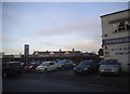
1
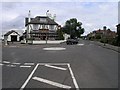
The Clifton Arms, Caterham
The Clifton Arms, established in 1869 on a roundabout road junction.
Image: © Hywel Williams
Taken: 28 Jul 2005
0.08 miles
3
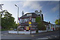
The Clifton Arms 2011
Used to be the soldiers pub of choice when the barracks were located at Caterham-on-the-Hill. Now well past it's best and ripe for re-development.
Image: © Kurseong Carl
Taken: 29 May 2011
0.10 miles
4
The Clifton Arms
May 2012. A favourite haunt of the guards based in the barracks when the soldiers were based in Caterham some years ago.
Image: © Kurseong Carl
Taken: 7 May 2012
0.10 miles
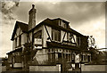
6
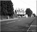
Clifton Arms, Caterham, Surrey
No connection with the photographer, but they appear to have got the coat of arms correct on the pub sign. This view is in 1971.
Additional note from observation, 26 August 2012: This public house has now been demolished.
Image: © Dr Neil Clifton
Taken: 19 Sep 1971
0.10 miles
7
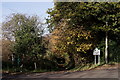
Bridleway to Coulsdon Common
Seen from the B2031 boundary of Chaldon and Caterham.
Image: © Peter Trimming
Taken: 17 Nov 2017
0.15 miles
8
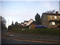
Roffes Lane at the junction of Chaldon Road
Image: © David Howard
Taken: 11 Dec 2016
0.15 miles
9
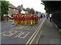
Caterham Carnival Parade
Disappointingly, this parade was not headed up by a brass band, (which used to be considered de rigueur on such occasions). However, further back there was a King Billy style fife and drum outfit.
Image: © Dr Neil Clifton
Taken: 13 Jun 2009
0.16 miles
10
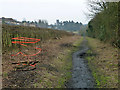
Green Lane, Caterham
A long straight lane with public bridleway status. It must have had heavier traffic in the past, as most of the way it has a more or less disintegrated tarmac surface. Possibly this was to do with the nearby Caterham Barracks, now closed and redeveloped. Recent scrub clearance has revealed a series of manholes with missing or broken covers, one is cordoned on the left.
Image: © Robin Webster
Taken: 1 Feb 2011
0.20 miles