IMAGES TAKEN NEAR TO
Town End Close, CATERHAM, CR3 5UQ
Introduction
This page details the photographs taken nearby to Town End Close, CR3 5UQ by members of the Geograph project.
The Geograph project started in 2005 with the aim of publishing, organising and preserving representative images for every square kilometre of Great Britain, Ireland and the Isle of Man.

There are currently over 7.5m images from over14,400 individuals and you can help contribute to the project by visiting https://www.geograph.org.uk
Image Map (Loading...)


Getting Data...Please wait
Leaflet Map data © OpenStreetMap
Images are licensed for reuse under creativecommons.org/licenses/by-sa/2.0
Notes
- Clicking on the map will re-center to the selected point.
- The higher the marker number, the further away the image location is from the centre of the postcode.
Image Listing (34 Images Found)
Images are licensed for reuse under creativecommons.org/licenses/by-sa/2.0
Image
Details
Distance
1
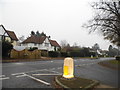
Townend at the junction of Banstead Road
Image: © David Howard
Taken: 17 Nov 2013
0.08 miles
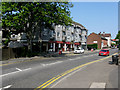
3
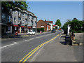
Caterham: Town End
Looking north. This road runs northward from the Golden Lion junction, and is frequently used by motorists on their way to Coulsdon, Purley or Croydon.
Image: © Dr Neil Clifton
Taken: 21 Apr 2011
0.11 miles
4
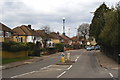
Buxton Lane, Kenley, Surrey
Looking in the direction of Kenley airfield. Once a quiet lane, now quite a busy road with a bus service.
Image: © Peter Trimming
Taken: 1 Apr 2010
0.13 miles
5

De Stafford College, Caterham, Surrey
A comprehensive school of Surrey Education Authority
Image: © Dr Neil Clifton
Taken: 24 Sep 2005
0.14 miles
6
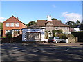
5-9 Town End, Caterham on the Hill
The building on the right, 5-7 Town End, is a grade II listed building. The listing description says 'Former farm house with shop attached. Circa 1640 with mid C19 extensions to left. Knapped flint with brick dressing to right, rendered on extension to left; plain tiled roof, half hipped to right with central rendered stack'
Image: © John Brightley
Taken: 17 Oct 2007
0.16 miles
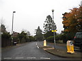
7
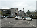
Town End car park, Caterham on the Hill
Image: © Robin Webster
Taken: 24 Jan 2011
0.16 miles
8
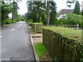
Whyteleafe Road, Caterham
Whyteleafe Road runs along the top of the western side of the Caterham Valley. As can be seen here it is very leafy.
Image: © Marathon
Taken: 4 Jul 2012
0.16 miles
9
The junction of Town End, Chaldon Road and High Street, Caterham
Image: © John Brightley
Taken: 17 Oct 2007
0.17 miles
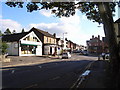
10
Caterham: Shops on Town End
These shops are on the west side of Town End.
Image: © Dr Neil Clifton
Taken: 21 Apr 2011
0.17 miles