IMAGES TAKEN NEAR TO
Foxon Lane, CATERHAM, CR3 5SD
Introduction
This page details the photographs taken nearby to Foxon Lane, CR3 5SD by members of the Geograph project.
The Geograph project started in 2005 with the aim of publishing, organising and preserving representative images for every square kilometre of Great Britain, Ireland and the Isle of Man.

There are currently over 7.5m images from over14,400 individuals and you can help contribute to the project by visiting https://www.geograph.org.uk
Image Map
Images are licensed for reuse under creativecommons.org/licenses/by-sa/2.0
Notes
- Clicking on the map will re-center to the selected point.
- The higher the marker number, the further away the image location is from the centre of the postcode.
Image Listing (11 Images Found)
Images are licensed for reuse under creativecommons.org/licenses/by-sa/2.0
Image
Details
Distance
1
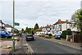
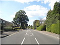
Foxon Lane
1930s housing in an existing lane. The footpath leads through to Buxton Lane.
Image: © Ian Capper
Taken: 12 Oct 2018
0.01 miles
2

Air ministry boundary marker
Air ministry boundary marker at one end of a footpath linking Foxon Lane and Buxton Lane. This dates from the Second World War and is associated with nearby RAF Kenley. There is a similar on at the other end of the footpath in Buxton Lane. For a wider view see Image
Image: © Ian Capper
Taken: 12 Oct 2018
0.01 miles
3
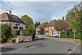
Fulford Road
Fill in housing in Fulford Road, with one of the original c1930s houses on the left.
Image: © Ian Capper
Taken: 12 Oct 2018
0.07 miles
4
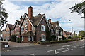
Buxton Lodge Care Home
Care home in Buxton Lane, housed in a large house built in 1871 originally called Greenlands.
Image: © Ian Capper
Taken: 12 Oct 2018
0.14 miles
5

Spencer Road
Housing on a 1950s extension of Spencer Road on what the 1935 1:2,500 map mark as allotment gardens.
Image: © Ian Capper
Taken: 12 Oct 2018
0.15 miles
6

Addison Road
Housing in Addison Road dating from various periods of the 20th Century.
Image: © Ian Capper
Taken: 12 Oct 2018
0.15 miles
7
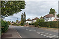
Buxton Lane
c1930s housing in Buxton Lane. Older maps name the road Buxton's Lane, and show a large house further along the lane called The Buckstones.
Image: © Ian Capper
Taken: 12 Oct 2018
0.16 miles
9
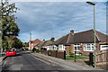
Addison Road
c1960s bungalows in Addison Road.
Image: © Ian Capper
Taken: 12 Oct 2018
0.18 miles
10
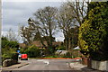
Road Junction on Buxton Lane, Kenley, Surrey
The Royal Mail van continues on Buxton Lane, towards Kenley airfield. Salmons Lane West comes in from the right. Ninehams Road is hidden, to the left.
Image: © Peter Trimming
Taken: 1 Apr 2010
0.23 miles