IMAGES TAKEN NEAR TO
Roffes Lane, CATERHAM, CR3 5PS
Introduction
This page details the photographs taken nearby to Roffes Lane, CR3 5PS by members of the Geograph project.
The Geograph project started in 2005 with the aim of publishing, organising and preserving representative images for every square kilometre of Great Britain, Ireland and the Isle of Man.

There are currently over 7.5m images from over14,400 individuals and you can help contribute to the project by visiting https://www.geograph.org.uk
Image Map (Loading...)


Getting Data...Please wait
Leaflet Map data © OpenStreetMap
Images are licensed for reuse under creativecommons.org/licenses/by-sa/2.0
Notes
- Clicking on the map will re-center to the selected point.
- The higher the marker number, the further away the image location is from the centre of the postcode.
Image Listing (12 Images Found)
Images are licensed for reuse under creativecommons.org/licenses/by-sa/2.0
Image
Details
Distance
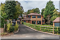
1
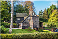
18 Roffe's Lane
One of a group of originally three houses in Roffe's Lane designed by the architect Ernest Trobridge, who was a proponent of the use of timber in construction in the 1920s. Of the other two, only no 20 remains, no 22 now having been replaced by a three house development called Trobridge Hill, completed in 2017 (see Image).
Image: © Ian Capper
Taken: 27 Oct 2018
0.00 miles
2
20 Roffe's Lane
One of a group of originally three houses in Roffe's Lane designed by the architect Ernest Trobridge, who was a proponent of the use of timber in construction in the 1920s. Of the other two, only no 18 remains (see Image), no 22 now having been replaced by a three house development called Trobridge Hill, completed in 2017 (see Image).
Image: © Ian Capper
Taken: 27 Oct 2018
0.02 miles
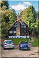
3
Trobridge Hill
Development of 3 houses on the site of 22 Roffe's Lane, completed in 2017. The name commemorates the architect Ernest Trobridge, who was a proponent of the use of timber in construction in the 1920s and who designed the original no 22, as well its two neighbours to the north, nos 18 and 20, which both remain (see Image and Image respectively).
Image: © Ian Capper
Taken: 12 Oct 2018
0.03 miles
4
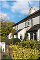
27 - 39 Roffe's Lane
Part of a 19th Century terrace in Roffe's Lane. For whole terrace see Image
Image: © Ian Capper
Taken: 27 Oct 2018
0.06 miles
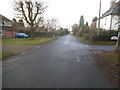
5

Chaldon
The eastern edge of the hamlet, on the B2031.
Image: © Peter Trimming
Taken: 17 Nov 2017
0.06 miles
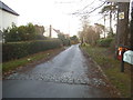
6
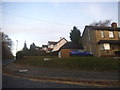
Roffes Lane at the junction of Chaldon Road
Image: © David Howard
Taken: 11 Dec 2016
0.07 miles
7

27 - 39 Roffe's Lane
19th Century terrace in Roffe's Lane.
Image: © Ian Capper
Taken: 12 Oct 2018
0.07 miles
8
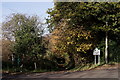
Bridleway to Coulsdon Common
Seen from the B2031 boundary of Chaldon and Caterham.
Image: © Peter Trimming
Taken: 17 Nov 2017
0.08 miles