IMAGES TAKEN NEAR TO
Birdwood Close, SOUTH CROYDON, CR2 8QG
Introduction
This page details the photographs taken nearby to Birdwood Close, CR2 8QG by members of the Geograph project.
The Geograph project started in 2005 with the aim of publishing, organising and preserving representative images for every square kilometre of Great Britain, Ireland and the Isle of Man.

There are currently over 7.5m images from over14,400 individuals and you can help contribute to the project by visiting https://www.geograph.org.uk
Image Map
Images are licensed for reuse under creativecommons.org/licenses/by-sa/2.0
Notes
- Clicking on the map will re-center to the selected point.
- The higher the marker number, the further away the image location is from the centre of the postcode.
Image Listing (49 Images Found)
Images are licensed for reuse under creativecommons.org/licenses/by-sa/2.0
Image
Details
Distance
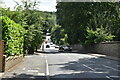
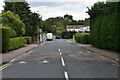
2
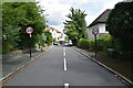
Old Farleigh Road, Selsdon
This road leads uphill from Farleigh towards the A2022 Addington Road.
In the background, on the left is a junction to Raveshead Close, a small close of houses.
Image: © David Anstiss
Taken: 23 Oct 2011
0.09 miles