IMAGES TAKEN NEAR TO
Farnborough Avenue, SOUTH CROYDON, CR2 8HD
Introduction
This page details the photographs taken nearby to Farnborough Avenue, CR2 8HD by members of the Geograph project.
The Geograph project started in 2005 with the aim of publishing, organising and preserving representative images for every square kilometre of Great Britain, Ireland and the Isle of Man.

There are currently over 7.5m images from over14,400 individuals and you can help contribute to the project by visiting https://www.geograph.org.uk
Image Map
Images are licensed for reuse under creativecommons.org/licenses/by-sa/2.0
Notes
- Clicking on the map will re-center to the selected point.
- The higher the marker number, the further away the image location is from the centre of the postcode.
Image Listing (5 Images Found)
Images are licensed for reuse under creativecommons.org/licenses/by-sa/2.0
Image
Details
Distance
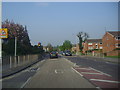
2
Selsdon Park Road, Forestdale, Croydon
Image: © Christopher Hilton
Taken: 30 Jun 2013
0.19 miles
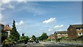
3

A2022 - Selsdon Park Road, looking towards Addington
Image: © Roger
Taken: 11 Sep 2008
0.20 miles
4
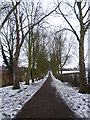
Path leading away from Gravel Hill
This path leads from Gravel Hill and the Tramlink stop towards Farnborough Avenue at Selsdon.
Image: © Marathon
Taken: 8 Feb 2012
0.23 miles
5
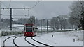
Winter Landscape on Gravel Hill
April 2008, and winter finally arrives! The red and white tram adds a splash of colour.
Image: © Peter Trimming
Taken: 6 Apr 2008
0.24 miles