IMAGES TAKEN NEAR TO
Norfolk Avenue, SOUTH CROYDON, CR2 8BW
Introduction
This page details the photographs taken nearby to Norfolk Avenue, CR2 8BW by members of the Geograph project.
The Geograph project started in 2005 with the aim of publishing, organising and preserving representative images for every square kilometre of Great Britain, Ireland and the Isle of Man.

There are currently over 7.5m images from over14,400 individuals and you can help contribute to the project by visiting https://www.geograph.org.uk
Image Map (Loading...)


Getting Data...Please wait
Leaflet Map data © OpenStreetMap
Images are licensed for reuse under creativecommons.org/licenses/by-sa/2.0
Notes
- Clicking on the map will re-center to the selected point.
- The higher the marker number, the further away the image location is from the centre of the postcode.
Image Listing (8 Images Found)
Images are licensed for reuse under creativecommons.org/licenses/by-sa/2.0
Image
Details
Distance
1
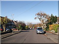
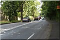
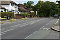
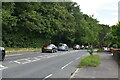
Norfolk Avenue, Sanderstead
This very long road twists and turns from Church Way to Upper Selsdon Road.
In the background is Littleheath Woods.
Image: © David Anstiss
Taken: 13 Nov 2011
0.13 miles
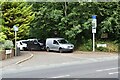
5
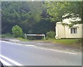
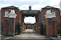
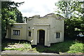
Path End
The path alongside the lodge to Selsdon Park on Addington Road, Selsdon.
Image: © Gordon Griffiths
Taken: 25 May 2018
0.24 miles