IMAGES TAKEN NEAR TO
Arundel Avenue, SOUTH CROYDON, CR2 8BE
Introduction
This page details the photographs taken nearby to Arundel Avenue, CR2 8BE by members of the Geograph project.
The Geograph project started in 2005 with the aim of publishing, organising and preserving representative images for every square kilometre of Great Britain, Ireland and the Isle of Man.

There are currently over 7.5m images from over14,400 individuals and you can help contribute to the project by visiting https://www.geograph.org.uk
Image Map (Loading...)


Getting Data...Please wait
Leaflet Map data © OpenStreetMap
Images are licensed for reuse under creativecommons.org/licenses/by-sa/2.0
Notes
- Clicking on the map will re-center to the selected point.
- The higher the marker number, the further away the image location is from the centre of the postcode.
Image Listing (13 Images Found)
Images are licensed for reuse under creativecommons.org/licenses/by-sa/2.0
Image
Details
Distance
1
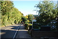
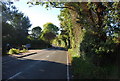
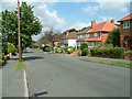
Norfolk Avenue, Sanderstead
This very long road twists and turns from Church Way to Upper Selsdon Road.
In the background is Littleheath Woods.
Image: © David Anstiss
Taken: 13 Nov 2011
0.17 miles
2
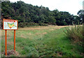
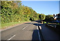
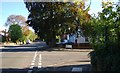
Littleheath Woods, Selsdon
64 acres of woodland with footpaths, bridle path and children's playground, Littleheath Woods is now a collective name for a number of woods which over the past 100 years have grown together, with a field on the north eastern side. The photo shows Littleheath Wood itself, across Clears Croft, from just inside the Brent Road entrance.
Image: © Philip Talmage
Taken: 16 Aug 2005
0.20 miles
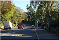
4
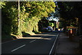
Langley Oaks Avenue off Upper Selsdon Rd
Image: © N Chadwick
Taken: 10 Oct 2010
0.21 miles