IMAGES TAKEN NEAR TO
Croham Valley Road, SOUTH CROYDON, CR2 7NB
Introduction
This page details the photographs taken nearby to Croham Valley Road, CR2 7NB by members of the Geograph project.
The Geograph project started in 2005 with the aim of publishing, organising and preserving representative images for every square kilometre of Great Britain, Ireland and the Isle of Man.

There are currently over 7.5m images from over14,400 individuals and you can help contribute to the project by visiting https://www.geograph.org.uk
Image Map (Loading...)


Getting Data...Please wait
Leaflet Map data © OpenStreetMap
Images are licensed for reuse under creativecommons.org/licenses/by-sa/2.0
Notes
- Clicking on the map will re-center to the selected point.
- The higher the marker number, the further away the image location is from the centre of the postcode.
Image Listing (23 Images Found)
Images are licensed for reuse under creativecommons.org/licenses/by-sa/2.0
Image
Details
Distance
1
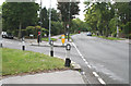
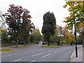
South Croydon: Croham Valley Road
Looking east from the bottom of Ballards Rise, we see the junction with Ballards Way to the left. Very few cars about, being a Bank Holiday.
Image: © Dr Neil Clifton
Taken: 5 Jun 2012
0.04 miles
4
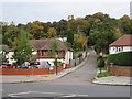
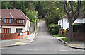
Ballards Rise, South Croydon
Ballards Rise is a residential cul-de-sac in South Croydon, in the outer suburbs of south London.
This image was taken in the month of October, as leaves were turning golden and starting to fall.
Image: © Malc McDonald
Taken: 20 Oct 2019
0.08 miles
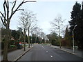
5
Road junction near Selsdon
The junction of Farley Road and Croham Valley Road near Selsdon, in south London's outer suburbs.
This image was taken in the month of October, as leaves were turning red and golden and starting to fall.
Image: © Malc McDonald
Taken: 20 Oct 2019
0.11 miles
6
Ballards Farm Road, South Croydon
Bridleway.
Image: © Philip Talmage
Taken: 15 Aug 2005
0.11 miles
7
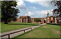
Royal Russell School, Croydon
Royal Russell School is a traditional English private school, in Coombe Lane, Croydon. Founded in 1853, it is a co-educational independent HMC day and boarding school in a 110-acre parkland setting. See http://www.royalrussell.co.uk/index.html
Image: © Philip Talmage
Taken: 15 Aug 2005
0.11 miles
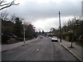
8
South Croydon: Ballards Rise
This small cul-de-sac is seen from Croham Valley Road
Image: © Dr Neil Clifton
Taken: 5 Jun 2012
0.11 miles
9
Ballards Farm Road
Running along the southern edge of the Coombe Wood estate.
Image: © Peter Trimming
Taken: 29 Jun 2018
0.12 miles
10

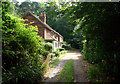
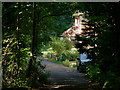
Cottages beside Ballards Farm Road
This unmade track leads from Ballards Way towards Croham Road, beside Coombe Wood (on the right). These two cottages are about halfway along the track.
The track is also used by the Vanguard Way (long distance path) leading towards Croham Road.
Image: © David Anstiss
Taken: 23 Oct 2011
0.12 miles