IMAGES TAKEN NEAR TO
Muggeridge Close, SOUTH CROYDON, CR2 7LB
Introduction
This page details the photographs taken nearby to Muggeridge Close, CR2 7LB by members of the Geograph project.
The Geograph project started in 2005 with the aim of publishing, organising and preserving representative images for every square kilometre of Great Britain, Ireland and the Isle of Man.

There are currently over 7.5m images from over14,400 individuals and you can help contribute to the project by visiting https://www.geograph.org.uk
Image Map
Images are licensed for reuse under creativecommons.org/licenses/by-sa/2.0
Notes
- Clicking on the map will re-center to the selected point.
- The higher the marker number, the further away the image location is from the centre of the postcode.
Image Listing (126 Images Found)
Images are licensed for reuse under creativecommons.org/licenses/by-sa/2.0
Image
Details
Distance
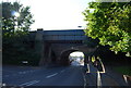
1
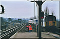
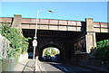
South end of South Croydon station
A "4-VEP" unit no. 3515 passes through South Croydon station as track maintenance contractors work on the bridge over Croham Road. The junction seen here marks a principal split in the Southern main line, the tracks to the left being the Uckfield and East Grinstead branches, and the other lines going straight on to Redhill and Brighton.
Image: © Stephen Craven
Taken: 9 Feb 2004
0.02 miles
3
South Croydon station, 2005
View south, towards Gatwick Airport, Brighton and the Sussex Coast ahead; the Oxted Line goes left at the end of the platforms. An Up Gatwick Express is speeding towards me on the Up Fast line.
Image: © Ben Brooksbank
Taken: 7 Aug 2005
0.03 miles
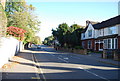
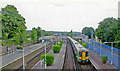
5
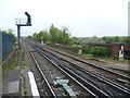
Looking down the line from South Croydon station
South Croydon station was originally a terminus, next to the Brighton Line but without any platforms on it. It was at the end of a one-mile extension of the local lines from London to New Croydon station, opened by the London Brighton & South Coast Railway in 1865. The aim was to provide more space for reversing local trains than could be afforded at the busy New Croydon station. In 1894 the railway obtained authority to extend the local line from South Croydon to Coulsdon, parallel to the existing main line. The station was rebuilt as a through station with platforms on all the lines prior to the opening of the new line in November 1899. This photograph looks southwards across the bridge crossing Croham Road. The fast lines are on the extreme right.
Image: © Marathon
Taken: 9 May 2012
0.04 miles