IMAGES TAKEN NEAR TO
Birdhurst Avenue, SOUTH CROYDON, CR2 7EU
Introduction
This page details the photographs taken nearby to Birdhurst Avenue, CR2 7EU by members of the Geograph project.
The Geograph project started in 2005 with the aim of publishing, organising and preserving representative images for every square kilometre of Great Britain, Ireland and the Isle of Man.

There are currently over 7.5m images from over14,400 individuals and you can help contribute to the project by visiting https://www.geograph.org.uk
Image Map
Images are licensed for reuse under creativecommons.org/licenses/by-sa/2.0
Notes
- Clicking on the map will re-center to the selected point.
- The higher the marker number, the further away the image location is from the centre of the postcode.
Image Listing (90 Images Found)
Images are licensed for reuse under creativecommons.org/licenses/by-sa/2.0
Image
Details
Distance
1
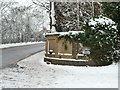
Old drinking fountain, corner of Water Tower Hill
On the corner with Coombe Road, although of some age, it has been moved here from a slightly different earlier position. On the 1895 plan it is shown in a small enclosure standing proud of the wall line here and rather narrowing locally the already not very wide Water Tower Hill.
Image: © Robin Webster
Taken: 19 Dec 2010
0.02 miles
2
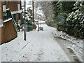
Looking down a snowy Water Tower Hill
Falling snow was getting on the camera lens.
Image: © Robin Webster
Taken: 19 Dec 2010
0.03 miles
3
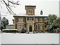
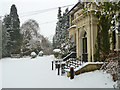
Coombe Cliff
Built for the Horniman family, of tea fame, and public benefactors. The blue plaque commemorates this. At present in limbo, having been disused for a few years after use for educational purposes. Planning permission has been granted for conversion into a care home, having regard for its grade II listed status. There is no sign of work having started on this yet.
Image: © Robin Webster
Taken: 19 Dec 2010
0.06 miles
4
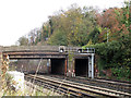
Coombe Road bridge
A bridge carrying Coombe Road across the main London-Brighton railway line in South Croydon. It appears to have a cast iron deck with brick parapets.
Image: © Stephen Craven
Taken: 2 Nov 2011
0.07 miles
5
In front of Coombe Cliff
Built for the Horniman family, of tea fame, and public benefactors. At the time of this view in limbo, having been disused for a few years after use for educational purposes. Planning permission has been granted for conversion into a care home, having regard for its grade II listed status. There was no sign of work having started on this.
Image: © Robin Webster
Taken: 19 Dec 2010
0.08 miles
6
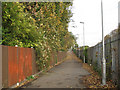
Cycle path to Coombe Road
This shared-use pedestrian / cycle path links South Croydon station to Coombe Road.
Image: © Stephen Craven
Taken: 2 Nov 2011
0.08 miles
7
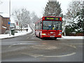
Route T33 bus in falling snow, Croydon
Coming out of South Park Hill Road and turning into Coombe Road.
Image: © Robin Webster
Taken: 19 Dec 2010
0.08 miles
8
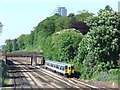
Approaching South Croydon
The railway line from East Croydon, with a train approaching South Croydon station.
Image: © Malc McDonald
Taken: 22 May 2010
0.09 miles
9
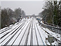
Snowy tracks north of South Croydon
The fast tracks are on the right.
Image: © Robin Webster
Taken: 19 Dec 2010
0.10 miles
10
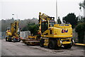
South Croydon
Vehicles involved with track ballasting on the railway line, beyond the fence, to the right of picture.
Image: © Peter Trimming
Taken: 9 Jan 2021
0.11 miles