IMAGES TAKEN NEAR TO
Birdhurst Road, SOUTH CROYDON, CR2 7EE
Introduction
This page details the photographs taken nearby to Birdhurst Road, CR2 7EE by members of the Geograph project.
The Geograph project started in 2005 with the aim of publishing, organising and preserving representative images for every square kilometre of Great Britain, Ireland and the Isle of Man.

There are currently over 7.5m images from over14,400 individuals and you can help contribute to the project by visiting https://www.geograph.org.uk
Image Map (Loading...)


Getting Data...Please wait
Leaflet Map data © OpenStreetMap
Images are licensed for reuse under creativecommons.org/licenses/by-sa/2.0
Notes
- Clicking on the map will re-center to the selected point.
- The higher the marker number, the further away the image location is from the centre of the postcode.
Image Listing (92 Images Found)
Images are licensed for reuse under creativecommons.org/licenses/by-sa/2.0
Image
Details
Distance
1
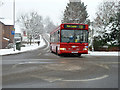
Route T33 bus in falling snow, Croydon
Coming out of South Park Hill Road and turning into Coombe Road.
Image: © Robin Webster
Taken: 19 Dec 2010
0.11 miles
2
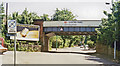
Coombe Road station, 1983
View eastward on A212 under the ex-SE&CR & LB&SCR Joint line, Woodside (to left) - Sanderstead (to right) branch, which had never been a success, latterly run down and had just been closed - on 15/5/83. The station had been 'Coombe Lane' until closed 1/1/17 and reopened as 'Coombe Road' on 30/9/35.
Image: © Ben Brooksbank
Taken: 19 Jun 1983
0.15 miles
3
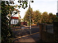
Footpath crosses Birdhurst Rise
A path leads from Croham Road through a part of suburban South Croydon towards Hurst Road near South Croydon Railway Station.
Image: © David Anstiss
Taken: 23 Oct 2011
0.16 miles
4
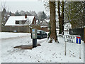
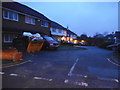
Stanhope Road, Croydon
Steep Hill is the name of a residential road off to the right, which is unlikely to be as steep as this stretch of Stanhope Road. Nothing special normally, but in this weather ...
Image: © Robin Webster
Taken: 19 Dec 2010
0.16 miles
5
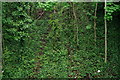
South Croydon
The overgrown trackbed of the former Woodside and South Croydon Joint Railway (opened 1885, closed 1983).
Image: © Peter Trimming
Taken: 29 Apr 2020
0.16 miles
6
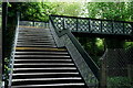
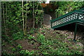
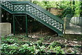
South Croydon
Footbridge across the overgrown trackbed of the former Woodside and South Croydon Joint Railway (opened 1885, closed 1983).
Image: © Peter Trimming
Taken: 29 Apr 2020
0.16 miles
8
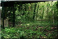
South Croydon
The overgrown trackbed of the former Woodside and South Croydon Joint Railway (opened 1885, closed 1983).
Image: © Peter Trimming
Taken: 29 Apr 2020
0.16 miles
9
South Croydon
The overgrown trackbed of the former Woodside and South Croydon Joint Railway (opened 1885, closed 1983).
Image: © Peter Trimming
Taken: 29 Apr 2020
0.17 miles
10
South Croydon
The overgrown trackbed of the former Woodside and South Croydon Joint Railway (opened 1885, closed 1983).
Image: © Peter Trimming
Taken: 29 Apr 2020
0.17 miles