IMAGES TAKEN NEAR TO
Normanton Road, SOUTH CROYDON, CR2 7AR
Introduction
This page details the photographs taken nearby to Normanton Road, CR2 7AR by members of the Geograph project.
The Geograph project started in 2005 with the aim of publishing, organising and preserving representative images for every square kilometre of Great Britain, Ireland and the Isle of Man.

There are currently over 7.5m images from over14,400 individuals and you can help contribute to the project by visiting https://www.geograph.org.uk
Image Map (Loading...)


Getting Data...Please wait
Leaflet Map data © OpenStreetMap
Images are licensed for reuse under creativecommons.org/licenses/by-sa/2.0
Notes
- Clicking on the map will re-center to the selected point.
- The higher the marker number, the further away the image location is from the centre of the postcode.
Image Listing (61 Images Found)
Images are licensed for reuse under creativecommons.org/licenses/by-sa/2.0
Image
Details
Distance
1
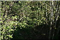
South Croydon
The overgrown trackbed of the former Woodside and South Croydon Joint Railway (opened 1885, closed 1983), looking away from the location of the Selsdon Road station.
Image: © Peter Trimming
Taken: 19 Apr 2020
0.07 miles
2
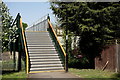
South Croydon
Footbridge across the overgrown trackbed of the former Woodside and South Croydon Joint Railway (opened 1885, closed 1983).
Image: © Peter Trimming
Taken: 19 Apr 2020
0.07 miles
3
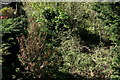
South Croydon
The overgrown trackbed of the former Woodside and South Croydon Joint Railway (opened 1885, closed 1983), looking towards the location of the Selsdon Road station.
Image: © Peter Trimming
Taken: 19 Apr 2020
0.08 miles
5
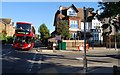
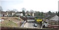
South Croydon
Croham Road, looking towards St.Peter's church. The railway line was closed in 1983.
Image: © Peter Trimming
Taken: 25 Dec 2019
0.13 miles
6
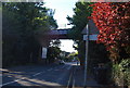
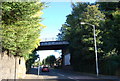
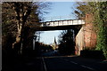
Railway bridge over Croham Rd
A former branch line crossed on this bridge.
Image: © N Chadwick
Taken: 10 Oct 2010
0.14 miles
7
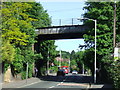
Disused railway bridge, Croham Road
Disused railway bridge across Croham Road. The bridge carried the Woodside to Sanderstead line, until its closure in 1983.
Image: © Malc McDonald
Taken: 22 May 2010
0.14 miles