IMAGES TAKEN NEAR TO
Kingsdown Avenue, SOUTH CROYDON, CR2 6QL
Introduction
This page details the photographs taken nearby to Kingsdown Avenue, CR2 6QL by members of the Geograph project.
The Geograph project started in 2005 with the aim of publishing, organising and preserving representative images for every square kilometre of Great Britain, Ireland and the Isle of Man.

There are currently over 7.5m images from over14,400 individuals and you can help contribute to the project by visiting https://www.geograph.org.uk
Image Map
Images are licensed for reuse under creativecommons.org/licenses/by-sa/2.0
Notes
- Clicking on the map will re-center to the selected point.
- The higher the marker number, the further away the image location is from the centre of the postcode.
Image Listing (57 Images Found)
Images are licensed for reuse under creativecommons.org/licenses/by-sa/2.0
Image
Details
Distance
1
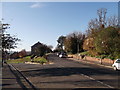
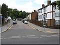
Junction on Kingswood Avenue
Kingswood Avenue leads up (on the right) from the A235 Brighton Road to Edgehill Road.
Montpelier Road leads left down to the A235 Brighton Road.
Image: © David Anstiss
Taken: 13 Nov 2011
0.03 miles
2
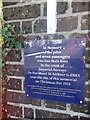
De Havilland Imperial Airways Crash
Memorial Plaque on Kingsdown Avenue. Under Image
See http://en.wikipedia.org/wiki/1924_Imperial_Airways_de_Havilland_DH.34_crash for more details about the crash.
Image: © David Anstiss
Taken: 13 Nov 2011
0.08 miles
3
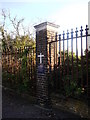
Aircraft Memorial on Kingsdown Avenue
A site of a plane crash in 1924.
See Image, for a close-up of the plaque.
See http://en.wikipedia.org/w/index.php?title=1924_Imperial_Airways_de_Havilland_DH.34_crash for more details about the crash.
Image: © David Anstiss
Taken: 13 Nov 2011
0.08 miles
4
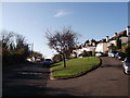
Crescent on Kingswood Avenue
Kingswood Avenue leads from the A235 Brighton Road, up to Edgehill Road.
Image: © David Anstiss
Taken: 13 Nov 2011
0.09 miles
5
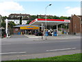
'On the Run' filling station, Purley Oaks
On the west side of Brighton Road. The brand of fuel available is Esso.
Image: © Dr Neil Clifton
Taken: 23 Aug 2008
0.09 miles
6
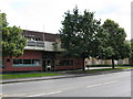
The 'Royal Oak', Purley Oaks
Surprisingly, the tree in front of the pub door actually is an oak.
Image: © Dr Neil Clifton
Taken: 23 Aug 2008
0.09 miles
7
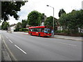
Brighton Road, Purley Oaks
Taken from the front of the 'Royal Oak' pub. The bus is an Arriva service on Route 407 from Caterham Station to Sutton, via Croydon. This route occasionally sees double deckers.
Note the older roadside housing in the distance on the right-hand side of the road.
Image: © Dr Neil Clifton
Taken: 23 Aug 2008
0.10 miles
8
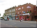
Shops, Brighton Road, Purley Oaks
This small group of shops on the west side of Brighton Road have never really prospered, as parking is difficult or impossible on this busy road.
Image: © Dr Neil Clifton
Taken: 23 Aug 2008
0.10 miles
9
Biddulph Road, Purley Oaks
This is the south end of Biddulph Road, which is on the west side of Brighton Road. It is a horseshoe-shaped road and returns to Brighton Road further up.
Image: © Dr Neil Clifton
Taken: 23 Aug 2008
0.10 miles
10
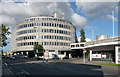
Capella Court, Brighton Road (1)
An iconic 1960s development, an office block joined by a walkway to a smaller retail development and car park.
It stands at the junction of Brighton and Riddlesdown Roads.
Image: © Stephen Richards
Taken: 4 Aug 2012
0.10 miles