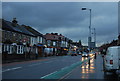
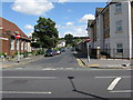
IMAGES TAKEN NEAR TO
Brighton Road, SOUTH CROYDON, CR2 6EG
Introduction
This page details the photographs taken nearby to Brighton Road, CR2 6EG by members of the Geograph project.
The Geograph project started in 2005 with the aim of publishing, organising and preserving representative images for every square kilometre of Great Britain, Ireland and the Isle of Man.

There are currently over 7.5m images from over14,400 individuals and you can help contribute to the project by visiting https://www.geograph.org.uk
Image Map
Images are licensed for reuse under creativecommons.org/licenses/by-sa/2.0
Notes
- Clicking on the map will re-center to the selected point.
- The higher the marker number, the further away the image location is from the centre of the postcode.
Image Listing (78 Images Found)
Images are licensed for reuse under creativecommons.org/licenses/by-sa/2.0
Image
Details
Distance
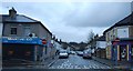
1
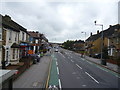
South Croydon: Brighton Road
Looking south. The 'Red Deer' is just visible in the far distance.
Image: © Dr Neil Clifton
Taken: 13 Nov 2014
0.03 miles

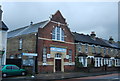
4

South Croydon Baptist Church
The brick building at the right is the Sunday School.
Image: © Dr Neil Clifton
Taken: 22 Jul 2009
0.04 miles


10
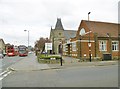
South Croydon, Brighton Road Baptist Church
With Sunday School in the foreground. http://www.brightonroadbaptist.org.uk/
Image: © Mike Faherty
Taken: 19 Mar 2016
0.08 miles