IMAGES TAKEN NEAR TO
Barnards Place, SOUTH CROYDON, CR2 6DZ
Introduction
This page details the photographs taken nearby to Barnards Place, CR2 6DZ by members of the Geograph project.
The Geograph project started in 2005 with the aim of publishing, organising and preserving representative images for every square kilometre of Great Britain, Ireland and the Isle of Man.

There are currently over 7.5m images from over14,400 individuals and you can help contribute to the project by visiting https://www.geograph.org.uk
Image Map
Images are licensed for reuse under creativecommons.org/licenses/by-sa/2.0
Notes
- Clicking on the map will re-center to the selected point.
- The higher the marker number, the further away the image location is from the centre of the postcode.
Image Listing (41 Images Found)
Images are licensed for reuse under creativecommons.org/licenses/by-sa/2.0
Image
Details
Distance
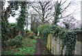
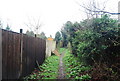
1
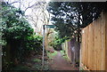
Footpath parallel to Mount Park Avenue (2)
Image: © N Chadwick
Taken: 27 Feb 2011
0.02 miles
3
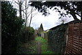
Footpath parallel to Mount Park Avenue (3)
Image: © N Chadwick
Taken: 27 Feb 2011
0.04 miles
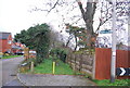
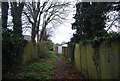
6
Footpath parallel to Mount park Avenue (4)
Image: © N Chadwick
Taken: 27 Feb 2011
0.08 miles
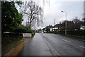
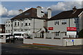
7
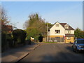
Edgehill Road, Purley
Edgehill Road is a minor residential road in Purley, in the outer suburbs of south London.
This image was taken on a February afternoon. Shadows were long as the sun is low in the sky at this time of year.
Image: © Malc McDonald
Taken: 19 Feb 2023
0.09 miles