IMAGES TAKEN NEAR TO
Columbine Avenue, SOUTH CROYDON, CR2 6DX
Introduction
This page details the photographs taken nearby to Columbine Avenue, CR2 6DX by members of the Geograph project.
The Geograph project started in 2005 with the aim of publishing, organising and preserving representative images for every square kilometre of Great Britain, Ireland and the Isle of Man.

There are currently over 7.5m images from over14,400 individuals and you can help contribute to the project by visiting https://www.geograph.org.uk
Image Map (Loading...)


Getting Data...Please wait
Leaflet Map data © OpenStreetMap
Images are licensed for reuse under creativecommons.org/licenses/by-sa/2.0
Notes
- Clicking on the map will re-center to the selected point.
- The higher the marker number, the further away the image location is from the centre of the postcode.
Image Listing (33 Images Found)
Images are licensed for reuse under creativecommons.org/licenses/by-sa/2.0
Image
Details
Distance
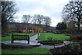
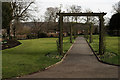
1
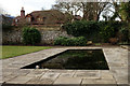
Haling Grove
The walled garden, within the park. The gate was locked, presumably because of the pond.
Image: © Peter Trimming
Taken: 10 Mar 2015
0.09 miles
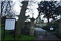
2
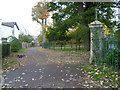
Haling Road alongside Haling Grove
Haling Grove was once part of the larger Haling Park country estate which reached as far as Duppas Hill. The house at Haling Grove was probably early Victorian, and was occupied by a succession of owners, the last being Mr Sydney Shorter, a London Merchant, who was frequently seen exercising his horses at Haling Grove, or riding a high trap through the town. Mr Shorter was also a breeder of horses and he also owned a Stud Farm at Cookham. He employed a coachman, two grooms and a stable boy at Haling Grove.
Mr Shorter died in 1929 and his wife who was not interested in horses did not continue to keep them. Mrs Sydney Shorter bequeathed Haling Grove to the Playing Fields Association in 1933 and they transferred it to Croydon Corporation. The house was demolished in 1936 and the lawn was extended over its site.
The main formal entrance to the park is just on the right here although Haling Road alongside is little more than a back alley.
Image: © Marathon
Taken: 7 Nov 2012
0.10 miles
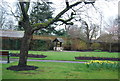
3
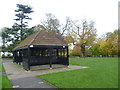
Shelter in Haling Grove
Haling Grove was once part of the larger Haling Park country estate which reached as far as Duppas Hill. The house at Haling Grove was probably early Victorian, and was occupied by a succession of owners, the last being Mr Sydney Shorter, a London Merchant, who was frequently seen exercising his horses at Haling Grove, or riding a high trap through the town. Mr Shorter was also a breeder of horses and he also owned a Stud Farm at Cookham. He employed a coachman, two grooms and a stable boy at Haling Grove.
Mr Shorter died in 1929 and his wife who was not interested in horses did not continue to keep them. Mrs Sydney Shorter bequeathed Haling Grove to the Playing Fields Association in 1933 and they transferred it to Croydon Corporation. The house was demolished in 1936 and the lawn was extended over its site.
The fine shelter is unusually large.
Image: © Marathon
Taken: 7 Nov 2012
0.10 miles
4
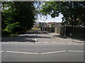
Kendra Hall Road
Off Pampisford Road Regina Coeli School on Kendra Hall Road
Image: © Shaun Ferguson
Taken: 26 Jun 2012
0.11 miles
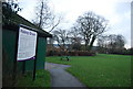
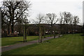
5
Haling Grove
A small park in South Croydon.
Image: © Peter Trimming
Taken: 10 Mar 2015
0.12 miles
6
Haling Grove
A small park in South Croydon, with one of the residents foraging on the grass.
Image: © Peter Trimming
Taken: 10 Mar 2015
0.12 miles