IMAGES TAKEN NEAR TO
Upper Selsdon Road, SOUTH CROYDON, CR2 0DU
Introduction
This page details the photographs taken nearby to Upper Selsdon Road, CR2 0DU by members of the Geograph project.
The Geograph project started in 2005 with the aim of publishing, organising and preserving representative images for every square kilometre of Great Britain, Ireland and the Isle of Man.

There are currently over 7.5m images from over14,400 individuals and you can help contribute to the project by visiting https://www.geograph.org.uk
Image Map
Images are licensed for reuse under creativecommons.org/licenses/by-sa/2.0
Notes
- Clicking on the map will re-center to the selected point.
- The higher the marker number, the further away the image location is from the centre of the postcode.
Image Listing (35 Images Found)
Images are licensed for reuse under creativecommons.org/licenses/by-sa/2.0
Image
Details
Distance
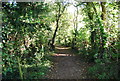
2
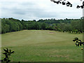
Down the fairway
A view from the public wood Croham Hurst of the adjacent golf course.
Image: © Robin Webster
Taken: 29 May 2011
0.10 miles
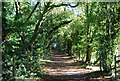
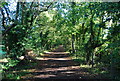
6
Wooded path across Croham Hurst Golf Course
The top most point of Croham Hurst lies some 477 feet above sea level and has been wooded for at least two hundred years. Croham Hurst became a very popular spot for people to visit in the late 19th century, but few people realised that the facility they freely enjoyed was not public property. In 1898 it became known that the owners, the Whitgift Governors, wished to dispose of the area. The lower slopes were to be developed and the remainder on the top offered to the Council.
This proposal would have resulted in half of Croham Hurst being built upon and the rest being enclosed behind a seven foot high fence. A campaign to save the site had strong backing from the papers who published a plan of the proposals which emphasised just how much of the area would be lost. Finally after a campaign, the Whitgift Foundation sold the whole of Croham Hurst to Croydon Corporation and it has since continued as a popular place for local people to visit.
The north-western part of Croham Hurst up to the main summit plateau is still wooded while the eastern and southern parts are taken up by Croham Hurst Golf Course. This is the view from the path which runs through a wooded strip between the two parts of the golf course on its way down to Upper Selsdon Road.
Image: © Marathon
Taken: 12 Sep 2012
0.13 miles
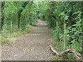
7

Woodland path across Croham Hurst Golf Course
The top most point of Croham Hurst lies some 477 feet above sea level and has been wooded for at least two hundred years. Croham Hurst became a very popular spot for people to visit in the late 19th century, but few people realised that the facility they freely enjoyed was not public property. In 1898 it became known that the owners, the Whitgift Governors, wished to dispose of the area. The lower slopes were to be developed and the remainder on the top offered to the Council.
This proposal would have resulted in half of Croham Hurst being built upon and the rest being enclosed behind a seven foot high fence. A campaign to save the site had strong backing from the papers who published a plan of the proposals which emphasised just how much of the area would be lost. Finally after a campaign, the Whitgift Foundation sold the whole of Croham Hurst to Croydon Corporation and it has since continued as a popular place for local people to visit.
The north-western part of Croham Hurst up to the main summit plateau is still wooded while the eastern and southern parts are taken up by Croham Hurst Golf Course. This is the view from the path which runs through a wooded strip between the two parts of the golf course on its way up from Upper Selsdon Road.
Image: © Marathon
Taken: 12 Sep 2012
0.14 miles
9
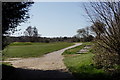
Croham Hurst Golf Course
Seen from the public bridleway.
Image: © Peter Trimming
Taken: 1 Apr 2020
0.16 miles