IMAGES TAKEN NEAR TO
The Lindens, CROYDON, CR0 9EL
Introduction
This page details the photographs taken nearby to The Lindens, CR0 9EL by members of the Geograph project.
The Geograph project started in 2005 with the aim of publishing, organising and preserving representative images for every square kilometre of Great Britain, Ireland and the Isle of Man.

There are currently over 7.5m images from over14,400 individuals and you can help contribute to the project by visiting https://www.geograph.org.uk
Image Map
Images are licensed for reuse under creativecommons.org/licenses/by-sa/2.0
Notes
- Clicking on the map will re-center to the selected point.
- The higher the marker number, the further away the image location is from the centre of the postcode.
Image Listing (14 Images Found)
Images are licensed for reuse under creativecommons.org/licenses/by-sa/2.0
Image
Details
Distance
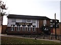
1
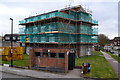
Block of flats undergoing maintenance
At the junction of Field Way and The Lindens. Bin store in the foreground.
Image: © David Martin
Taken: 3 Apr 2015
0.05 miles
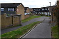
2

Fieldway Community Centre, New Addington
This metal shed building is on the road at the northern end of the village.
Image: © David Anstiss
Taken: 23 Oct 2011
0.17 miles
3
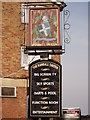
Randall Tavern, Pub Sign (1), New Addington
Outside Image on Fieldway.
Another sign is behind the pub.
Image: © David Anstiss
Taken: 23 Oct 2011
0.17 miles
4
Behind the Randall Tavern, New Addington
This pub on Fieldway.
Has another sign is behind the pub.
Compare with Image
Image: © David Anstiss
Taken: 23 Oct 2011
0.17 miles
5
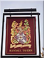
Randall Tavern, Pub Sign (2), New Addington
Image: © David Anstiss
Taken: 23 Oct 2011
0.17 miles
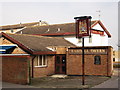
6
Randall Tavern, New Addington
Image: © David Anstiss
Taken: 23 Oct 2011
0.17 miles
8
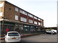
Fieldway Shops, New Addington
Local shops on Fieldway (road).
Image: © David Anstiss
Taken: 23 Oct 2011
0.17 miles
9
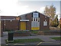
Wolsey Chapel, Dunley Drive
This chapel houses New Addington Community Church, a 1980s church plant in this ex council estate.
Image: © Ian Capper
Taken: 1 Apr 2008
0.20 miles
10
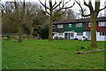
Houses and woodland at the northern corner of New Addington
Image: © David Martin
Taken: 3 Apr 2015
0.20 miles