IMAGES TAKEN NEAR TO
Underwood, CROYDON, CR0 9EH
Introduction
This page details the photographs taken nearby to Underwood, CR0 9EH by members of the Geograph project.
The Geograph project started in 2005 with the aim of publishing, organising and preserving representative images for every square kilometre of Great Britain, Ireland and the Isle of Man.

There are currently over 7.5m images from over14,400 individuals and you can help contribute to the project by visiting https://www.geograph.org.uk
Image Map
Images are licensed for reuse under creativecommons.org/licenses/by-sa/2.0
Notes
- Clicking on the map will re-center to the selected point.
- The higher the marker number, the further away the image location is from the centre of the postcode.
Image Listing (5 Images Found)
Images are licensed for reuse under creativecommons.org/licenses/by-sa/2.0
Image
Details
Distance
1
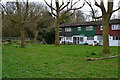
Houses and woodland at the northern corner of New Addington
Image: © David Martin
Taken: 3 Apr 2015
0.03 miles
2
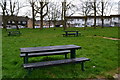
Picnic table beside recreation ground at New Addington
Image: © David Martin
Taken: 3 Apr 2015
0.15 miles
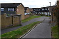
4
Block of flats undergoing maintenance
At the junction of Field Way and The Lindens. Bin store in the foreground.
Image: © David Martin
Taken: 3 Apr 2015
0.21 miles
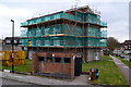
5
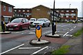
Traffic calming measures in Field Way, New Addington
Image: © David Martin
Taken: 3 Apr 2015
0.24 miles