IMAGES TAKEN NEAR TO
Elmside, CROYDON, CR0 9DT
Introduction
This page details the photographs taken nearby to Elmside, CR0 9DT by members of the Geograph project.
The Geograph project started in 2005 with the aim of publishing, organising and preserving representative images for every square kilometre of Great Britain, Ireland and the Isle of Man.

There are currently over 7.5m images from over14,400 individuals and you can help contribute to the project by visiting https://www.geograph.org.uk
Image Map
Images are licensed for reuse under creativecommons.org/licenses/by-sa/2.0
Notes
- Clicking on the map will re-center to the selected point.
- The higher the marker number, the further away the image location is from the centre of the postcode.
Image Listing (21 Images Found)
Images are licensed for reuse under creativecommons.org/licenses/by-sa/2.0
Image
Details
Distance
1
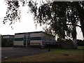
Applegarth Infant School, New Addington
As seen from near Fieldway.
Image: © David Anstiss
Taken: 23 Oct 2011
0.05 miles
2
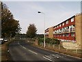
Fieldway, New Addington
This road leads from Lodge Lane around the northern end of the village.
Image: © David Anstiss
Taken: 23 Oct 2011
0.12 miles
3
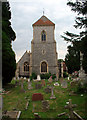
St Mary's, Addington Village, CR0
The church of St. Mary the Blessed Virgin, Addington, is over 900 years old. Five archbishops of Canterbury lie buried here. This is the view from the west. The tower was rebuilt in 1876.
Image: © Philip Talmage
Taken: 2 Aug 2005
0.13 miles
4
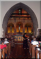
St Mary's, Addington Village, CR0
The church of St. Mary the Blessed Virgin, Addington, is over 900 years old. Five archbishops of Canterbury lie buried here. The chancel is the oldest part of the church, built around 1080. The pre-Raphaelite wall painting was completed in 1898, as part of a memorial to Archbishop Benson. This photograph was taken during a concert performed as part of the church's arts festival (soloist: Miho Hakamata).
Image: © Philip Talmage
Taken: 11 Sep 2005
0.13 miles
5
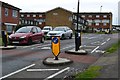
Traffic calming measures in Field Way, New Addington
Image: © David Martin
Taken: 3 Apr 2015
0.16 miles
6
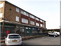
Fieldway Shops, New Addington
Local shops on Fieldway (road).
Image: © David Anstiss
Taken: 23 Oct 2011
0.17 miles
7
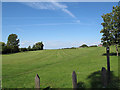
Open land north of Lodge Lane
There is no fencing or "private land" sign, so I presume this is a public open space.
Image: © Stephen Craven
Taken: 24 Jul 2011
0.18 miles
8
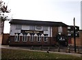
Randall Tavern, New Addington
Image: © David Anstiss
Taken: 23 Oct 2011
0.19 miles
9
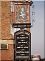
Randall Tavern, Pub Sign (1), New Addington
Outside Image on Fieldway.
Another sign is behind the pub.
Image: © David Anstiss
Taken: 23 Oct 2011
0.19 miles
10
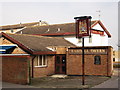
Behind the Randall Tavern, New Addington
This pub on Fieldway.
Has another sign is behind the pub.
Compare with Image
Image: © David Anstiss
Taken: 23 Oct 2011
0.20 miles